
Fraser Island topographic map
Interactive map
Click on the map to display elevation.
About this map
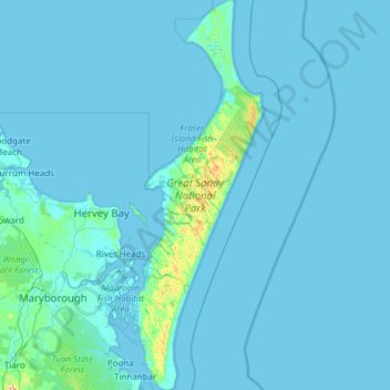
Name: Fraser Island topographic map, elevation, terrain.
Location: Fraser Island, Bundaberg Region, Queensland, Australia (-25.79749 152.94269 -24.69714 153.36028)
Average elevation: 36 ft
Minimum elevation: -7 ft
Maximum elevation: 1,257 ft
Other topographic maps
Click on a map to view its topography, its elevation and its terrain.
Bargara
Australia > Queensland > Bundaberg Region
Bargara, Bundaberg Region, Queensland, Australia
Average elevation: 26 ft
Bundaberg Central
Australia > Queensland > Bundaberg Region
Bundaberg Central, Bundaberg Region, Queensland, 4670, Australia
Average elevation: 39 ft
Kendall Flat
Australia > Queensland > Bundaberg Region > Bundaberg
Kendall Flat, Bundaberg East, Bundaberg, Bundaberg Region, Queensland, Australia
Average elevation: 36 ft
Innes Park
Australia > Queensland > Bundaberg Region > Innes Park
Innes Park, Bundaberg Region, Queensland, Australia
Average elevation: 49 ft