
Ferrol topographic map
Interactive map
Click on the map to display elevation.
About this map
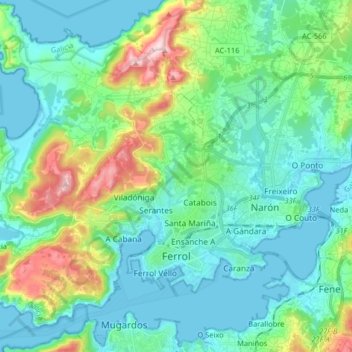
Name: Ferrol topographic map, elevation, terrain.
Location: Ferrol, A Coruña, Galicia, Spain (43.45319 -8.34810 43.56930 -8.18606)
Average elevation: 220 ft
Minimum elevation: -7 ft
Maximum elevation: 988 ft
Other topographic maps
Click on a map to view its topography, its elevation and its terrain.
Pena de Xacín
Spain > Galicia > Ferrol > Moeche
Pena de Xacín, Moeche, Ferrol, A Coruña, Galicia, 15563, Spain
Average elevation: 663 ft