
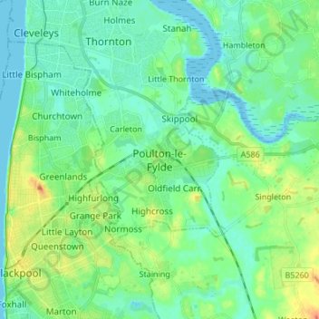
Poulton-le-Fylde topographic map
Interactive map
Click on the map to display elevation.
About this map
Name: Poulton-le-Fylde topographic map, elevation, terrain.
Average elevation: 39 ft
Minimum elevation: -7 ft
Maximum elevation: 141 ft
Other topographic maps
Click on a map to view its topography, its elevation and its terrain.
Hardhorn
United Kingdom > England > Lancashire > Borough of Wyre
Hardhorn, Borough of Wyre, Lancashire, England, FY6 8DN, United Kingdom
Average elevation: 43 ft
Little Thornton
United Kingdom > England > Lancashire > Borough of Wyre
Little Thornton, Borough of Wyre, Lancashire, England, FY5 5LU, United Kingdom
Average elevation: 26 ft
Parlick
United Kingdom > England > Lancashire > Borough of Wyre
Parlick, Borough of Wyre, Lancashire, England, PR3 2NZ, United Kingdom
Average elevation: 823 ft
River Brock
United Kingdom > England > Lancashire > Borough of Wyre
River Brock, Borough of Wyre, Lancashire, England, United Kingdom
Average elevation: 364 ft
St Michael's on Wyre
United Kingdom > England > Lancashire > Borough of Wyre
St Michael's on Wyre, Borough of Wyre, Lancashire, England, PR3 0TE, United Kingdom
Average elevation: 33 ft
Out Rawcliffe
United Kingdom > England > Lancashire > Borough of Wyre
Out Rawcliffe, Borough of Wyre, Lancashire, England, United Kingdom
Average elevation: 33 ft
Myerscough
United Kingdom > England > Lancashire > Borough of Wyre
Myerscough, Myerscough and Bilsborrow, Borough of Wyre, Lancashire, England, PR3 0RS, United Kingdom
Average elevation: 56 ft
Fleetwood
United Kingdom > England > Lancashire > Borough of Wyre
Fleetwood, Borough of Wyre, Lancashire, England, United Kingdom
Average elevation: 7 ft
Fair Snape Fell
United Kingdom > England > Lancashire > Borough of Wyre
Fair Snape Fell, Borough of Wyre, Lancashire, England, PR3 2NZ, United Kingdom
Average elevation: 1,332 ft
Garstang
United Kingdom > England > Lancashire > Borough of Wyre
Garstang, Borough of Wyre, Lancashire, England, United Kingdom
Average elevation: 79 ft
Great Eccleston
United Kingdom > England > Lancashire > Borough of Wyre
Great Eccleston, Borough of Wyre, Lancashire, England, United Kingdom
Average elevation: 39 ft
Bilsborrow
United Kingdom > England > Lancashire > Borough of Wyre
Bilsborrow, Myerscough and Bilsborrow, Borough of Wyre, Lancashire, England, PR3 0QR, United Kingdom
Average elevation: 92 ft
Preesall
United Kingdom > England > Lancashire > Borough of Wyre
Preesall, Borough of Wyre, Lancashire, England, United Kingdom
Average elevation: 10 ft
Hambleton
United Kingdom > England > Lancashire > Borough of Wyre > Hambleton
Hambleton, Borough of Wyre, Lancashire, North West England, England, United Kingdom
Average elevation: 30 ft
Catterall
United Kingdom > England > Lancashire > Borough of Wyre
Catterall, Borough of Wyre, Lancashire, England, PR3 0LR, United Kingdom
Average elevation: 72 ft
Oakenclough
United Kingdom > England > Lancashire > Borough of Wyre
Oakenclough, Bleasdale, Borough of Wyre, Lancashire, England, PR3 1UL, United Kingdom
Average elevation: 676 ft
Forton
United Kingdom > England > Lancashire > Borough of Wyre
Forton, Borough of Wyre, Lancashire, England, PR3 0BG, United Kingdom
Average elevation: 98 ft
Thornton
United Kingdom > England > Lancashire > Borough of Wyre
Thornton, Borough of Wyre, Lancashire, England, FY5 4AF, United Kingdom
Average elevation: 23 ft