
Mainz topographic map
Interactive map
Click on the map to display elevation.
About this map
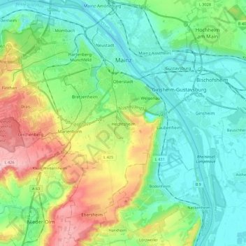
Name: Mainz topographic map, elevation, terrain.
Location: Mainz, Rhineland-Palatinate, Germany (49.89553 8.14309 50.03530 8.34226)
Average elevation: 430 ft
Minimum elevation: 256 ft
Maximum elevation: 856 ft
Nevertheless, the post-war reconstruction took place very slowly. While cities such as Frankfurt had been rebuilt fast by a central authority, only individual efforts were initially successful in rebuilding Mainz. The reason for this was that the French wanted Mainz to expand and become a model city. Mainz lay within the French-controlled sector of Germany and it was a French architect and town-planner, Marcel Lods, who produced a Le Corbusier-style plan of an ideal architecture. But the very first interest of the inhabitants was the restoration of housing areas. Even after the failure of the model city plans it was the initiative of the French (founding of the Johannes Gutenberg University of Mainz, elevation of Mainz to the state capital of Rhineland-Palatinate, the early resumption of the Mainz carnival) driving the city in a positive development after the war. The City Plan of 1958 by Ernst May allowed a regulated reconstruction for the first time. In 1950, the seat of the government of Rhineland-Palatinate had been transferred to the new Mainz and in 1963 the seat of the new ZDF, notable architects were Adolf Bayer, Richard Jörg and Egon Hartmann. At the time of the two-thousand-years-anniversary in 1962 the city was largely reconstructed. During the 1950s and 1960s, the Oberstadt had been extended, Münchfeld and Lerchenberg added as suburbs, the Altstadttangente (intersection of the old town), new neighbourhoods as Westring and Südring contributed to the extension. By 1970 there remained only a few ruins. The new town hall of Mainz had been designed by Arne Jacobsen and finished by Dissing+Weitling. The town used Jacobsens activity for the Danish Novo erecting a new office and warehouse building to contact him. The urban renewal of the old town changed the inner city. In the framework of the preparation of the cathedrals millennium, pedestrian zones were developed around the cathedral, in northern direction to the Neubrunnenplatz and in a southern direction across the Leichhof to the Augustinerstraße and Kirschgarten. The 1980s brought the renewal of the façades on the Markt and a new inner-city neighbourhood on the Kästrich. During the 1990s the Kisselberg between Gonsenheim and Bretzenheim, the "Fort Malakoff Center" at the site of the old police barracks, the renewal of the Main Station and the demolition of the first post-war shopping centre at the Markt followed by the erection of a new historicising building at the same place.
Other topographic maps
Click on a map to view its topography, its elevation and its terrain.
Nürburg
Germany > Rhineland-Palatinate > Landkreis Ahrweiler
Nürburg, Adenau, Landkreis Ahrweiler, Rhineland-Palatinate, Germany
Average elevation: 1,837 ft
Bullay
Germany > Rhineland-Palatinate > Landkreis Cochem-Zell
Bullay, Zell (Mosel), Landkreis Cochem-Zell, Rhineland-Palatinate, Germany
Average elevation: 679 ft
Mittelreidenbach
Germany > Rhineland-Palatinate > Landkreis Birkenfeld
Mittelreidenbach, Herrstein-Rhaunen, Landkreis Birkenfeld, Rhineland-Palatinate, Germany
Average elevation: 1,115 ft
Zilsdorf
Germany > Rhineland-Palatinate > Landkreis Vulkaneifel
Zilsdorf, Walsdorf, Gerolstein, Landkreis Vulkaneifel, Rhineland-Palatinate, 54578, Germany
Average elevation: 1,703 ft
Volkesfeld
Germany > Rhineland-Palatinate > Landkreis Mayen-Koblenz
Volkesfeld, Mendig, Landkreis Mayen-Koblenz, Rhineland-Palatinate, Germany
Average elevation: 1,407 ft
Herresbach
Germany > Rhineland-Palatinate > Landkreis Mayen-Koblenz
Herresbach, Vordereifel, Landkreis Mayen-Koblenz, Rhineland-Palatinate, Germany
Average elevation: 1,759 ft
Sponheim
Germany > Rhineland-Palatinate > Landkreis Bad Kreuznach
Sponheim, Rüdesheim, Landkreis Bad Kreuznach, Rhineland-Palatinate, Germany
Average elevation: 919 ft
Dünebusch
Germany > Rhineland-Palatinate > Landkreis Altenkirchen (Westerwald) > Bitzen
Dünebusch, Bitzen, Hamm (Sieg), Landkreis Altenkirchen (Westerwald), Rhineland-Palatinate, 57539, Germany
Average elevation: 676 ft
Kallstadt
Germany > Rhineland-Palatinate > Landkreis Bad Dürkheim
Kallstadt, Freinsheim, Landkreis Bad Dürkheim, Rhineland-Palatinate, 67169, Germany
Average elevation: 669 ft
Remagen
Germany > Rhineland-Palatinate > Landkreis Ahrweiler
Remagen, Landkreis Ahrweiler, Rhineland-Palatinate, Germany
Average elevation: 551 ft
Waldfischbach-Burgalben
Germany > Rhineland-Palatinate > Südwestpfalz
Waldfischbach-Burgalben, Südwestpfalz, Rhineland-Palatinate, 67714, Germany
Average elevation: 1,115 ft
Mähren
Germany > Rhineland-Palatinate > Westerwaldkreis
Mähren, Wallmerod, Westerwaldkreis, Rhineland-Palatinate, Germany
Average elevation: 1,207 ft
Eichenbach
Germany > Rhineland-Palatinate > Landkreis Ahrweiler
Eichenbach, Adenau, Landkreis Ahrweiler, Rhineland-Palatinate, 53533, Germany
Average elevation: 1,424 ft
Bleialf
Germany > Rhineland-Palatinate > Eifelkreis Bitburg-Prüm
Bleialf, Prüm, Eifelkreis Bitburg-Prüm, Rhineland-Palatinate, Germany
Average elevation: 1,654 ft
Lützkampen
Germany > Rhineland-Palatinate > Eifelkreis Bitburg-Prüm
Lützkampen, Arzfeld, Eifelkreis Bitburg-Prüm, Rhineland-Palatinate, 54617, Germany
Average elevation: 1,644 ft
Rheinböllen
Germany > Rhineland-Palatinate > Rhein-Hunsrück-Kreis
Rheinböllen, Simmern-Rheinböllen, Rhein-Hunsrück-Kreis, Rhineland-Palatinate, 55494, Germany
Average elevation: 1,483 ft
Ittel
Germany > Rhineland-Palatinate > Landkreis Trier-Saarburg
Ittel, Welschbillig, Trier-Land, Landkreis Trier-Saarburg, Rhineland-Palatinate, 54664, Germany
Average elevation: 997 ft
Meddersheim
Germany > Rhineland-Palatinate > Landkreis Bad Kreuznach
Meddersheim, Nahe-Glan, Landkreis Bad Kreuznach, Rhineland-Palatinate, Germany
Average elevation: 748 ft
Eppenbrunn
Germany > Rhineland-Palatinate > Südwestpfalz
Eppenbrunn, Pirmasens-Land, Südwestpfalz, Rhineland-Palatinate, Germany
Average elevation: 1,142 ft
Deidesheim
Germany > Rhineland-Palatinate > Landkreis Bad Dürkheim
Deidesheim, Landkreis Bad Dürkheim, Rhineland-Palatinate, 67146, Germany
Average elevation: 636 ft
Damscheid
Germany > Rhineland-Palatinate > Rhein-Hunsrück-Kreis
Damscheid, Hunsrück-Mittelrhein, Rhein-Hunsrück-Kreis, Rhineland-Palatinate, Germany
Average elevation: 1,142 ft
Bad Marienberg (Westerwald)
Germany > Rhineland-Palatinate > Westerwaldkreis
Bad Marienberg (Westerwald), Westerwaldkreis, Rhineland-Palatinate, 56470, Germany
Average elevation: 1,585 ft
Idar-Oberstein
Germany > Rhineland-Palatinate > Landkreis Birkenfeld
Idar-Oberstein, Landkreis Birkenfeld, Rhineland-Palatinate, 55743, Germany
Average elevation: 1,332 ft
Bärenbach
Germany > Rhineland-Palatinate > Rhein-Hunsrück-Kreis
Bärenbach, Kirchberg (Hunsrück), Rhein-Hunsrück-Kreis, Rhineland-Palatinate, Germany
Average elevation: 1,499 ft
Seesbach
Germany > Rhineland-Palatinate > Landkreis Bad Kreuznach
Seesbach, Nahe-Glan, Landkreis Bad Kreuznach, Rhineland-Palatinate, 55629, Germany
Average elevation: 1,263 ft
Feusdorf
Germany > Rhineland-Palatinate > Landkreis Vulkaneifel
Feusdorf, Gerolstein, Landkreis Vulkaneifel, Rhineland-Palatinate, Germany
Average elevation: 1,650 ft
Föhren
Germany > Rhineland-Palatinate > Landkreis Trier-Saarburg
Föhren, Schweich an der Römischen Weinstraße, Landkreis Trier-Saarburg, Rhineland-Palatinate, 54343, Germany
Average elevation: 830 ft
Charlottenberg
Germany > Rhineland-Palatinate > Rhein-Lahn-Kreis
Charlottenberg, Diez, Rhein-Lahn-Kreis, Rhineland-Palatinate, Germany
Average elevation: 873 ft
Piesport
Germany > Rhineland-Palatinate > Landkreis Bernkastel-Wittlich
Piesport, Bernkastel-Kues, Landkreis Bernkastel-Wittlich, Rhineland-Palatinate, 54498, Germany
Average elevation: 807 ft
Frankeneck
Germany > Rhineland-Palatinate > Landkreis Bad Dürkheim
Frankeneck, Lambrecht (Pfalz), Landkreis Bad Dürkheim, Rhineland-Palatinate, Germany
Average elevation: 1,066 ft
Ulmen
Germany > Rhineland-Palatinate > Landkreis Cochem-Zell
Ulmen, Landkreis Cochem-Zell, Rhineland-Palatinate, 56766, Germany
Average elevation: 1,493 ft
Wittlich
Germany > Rhineland-Palatinate > Landkreis Bernkastel-Wittlich > Wittlich
Wittlich, Landkreis Bernkastel-Wittlich, Rhineland-Palatinate, 54516, Germany
Average elevation: 778 ft
Alzey
Germany > Rhineland-Palatinate > Landkreis Alzey-Worms
Alzey, Landkreis Alzey-Worms, Rhineland-Palatinate, Germany
Average elevation: 728 ft
Neustadt an der Weinstraße
Germany > Rhineland-Palatinate
Neustadt an der Weinstraße, Rhineland-Palatinate, Germany
Average elevation: 820 ft
Bellheim
Germany > Rhineland-Palatinate > Landkreis Germersheim
Bellheim, Landkreis Germersheim, Rhineland-Palatinate, 76756, Germany
Average elevation: 390 ft
Rapperath
Germany > Rhineland-Palatinate > Landkreis Bernkastel-Wittlich > Morbach
Rapperath, Morbach, Landkreis Bernkastel-Wittlich, Rhineland-Palatinate, Germany
Average elevation: 1,490 ft
Bad Kreuznach
Germany > Rhineland-Palatinate > Landkreis Bad Kreuznach
Bad Kreuznach, Landkreis Bad Kreuznach, Rhineland-Palatinate, Germany
Average elevation: 591 ft
Grünstadt
Germany > Rhineland-Palatinate > Landkreis Bad Dürkheim
Grünstadt, Landkreis Bad Dürkheim, Rhineland-Palatinate, Germany
Average elevation: 682 ft
Hallenbad Idar-Oberstein
Germany > Rhineland-Palatinate > Landkreis Birkenfeld > Idar-Oberstein
Hallenbad Idar-Oberstein, 213, Hauptstraße, Idar, Idar-Oberstein, Landkreis Birkenfeld, Rhineland-Palatinate, 55743, Germany
Average elevation: 1,125 ft
Tiefenbach
Germany > Rhineland-Palatinate > Rhein-Hunsrück-Kreis
Tiefenbach, Simmern-Rheinböllen, Rhein-Hunsrück-Kreis, Rhineland-Palatinate, Germany
Average elevation: 1,371 ft
Nierstein
Germany > Rhineland-Palatinate > Landkreis Mainz-Bingen
Nierstein, Rhein-Selz, Landkreis Mainz-Bingen, Rhineland-Palatinate, 55283, Germany
Average elevation: 407 ft
Osthofen
Germany > Rhineland-Palatinate > Landkreis Alzey-Worms
Osthofen, Wonnegau, Landkreis Alzey-Worms, Rhineland-Palatinate, 67574, Germany
Average elevation: 344 ft
Bad Dürkheim
Germany > Rhineland-Palatinate > Landkreis Bad Dürkheim
Bad Dürkheim, Landkreis Bad Dürkheim, Rhineland-Palatinate, 67098, Germany
Average elevation: 709 ft
Hettenleidelheim
Germany > Rhineland-Palatinate > Landkreis Bad Dürkheim
Hettenleidelheim, Leiningerland, Landkreis Bad Dürkheim, Rhineland-Palatinate, 67310, Germany
Average elevation: 873 ft
Walporzheim
Germany > Rhineland-Palatinate > Landkreis Ahrweiler > Bad Neuenahr-Ahrweiler
Walporzheim, Bad Neuenahr-Ahrweiler, Landkreis Ahrweiler, Rhineland-Palatinate, Germany
Average elevation: 719 ft
Trier
Germany > Rhineland-Palatinate > Trier > Trier
Trier, Rhineland-Palatinate, 54290, Germany
Average elevation: 1,030 ft
Wolfstein
Germany > Rhineland-Palatinate > Landkreis Kusel
Wolfstein, Lauterecken-Wolfstein, Landkreis Kusel, Rhineland-Palatinate, 67752, Germany
Average elevation: 1,073 ft
Moselhöhe Ediger-Eller
Germany > Rhineland-Palatinate > Landkreis Cochem-Zell > Ediger-Eller
Moselhöhe Ediger-Eller, Ediger-Eller, Cochem, Landkreis Cochem-Zell, Rhineland-Palatinate, 56814, Germany
Average elevation: 935 ft
Helmbach
Germany > Rhineland-Palatinate > Landkreis Bad Dürkheim
Helmbach, Elmstein, Lambrecht (Pfalz), Landkreis Bad Dürkheim, Rhineland-Palatinate, 67472, Germany
Average elevation: 1,060 ft
Zell (Mosel)
Germany > Rhineland-Palatinate > Landkreis Cochem-Zell
Zell (Mosel), Landkreis Cochem-Zell, Rhineland-Palatinate, 56856, Germany
Average elevation: 942 ft