
Dharamshala topographic map
Interactive map
Click on the map to display elevation.
About this map
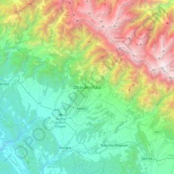
Name: Dharamshala topographic map, elevation, terrain.
Location: Dharamshala, Kangra District, Himachal Pradesh, 176200, India (32.05430 76.15967 32.37430 76.47967)
Average elevation: 5,843 ft
Minimum elevation: 1,591 ft
Maximum elevation: 16,106 ft
Dharamshala has an average elevation of 1,457 m (4,780 ft), covering an area of almost 8.51 km2 (3.29 sq mi). Dharamsala is located in the Kangra Valley, in the shadow of the Dhauladhar mountains.
Other topographic maps
Click on a map to view its topography, its elevation and its terrain.
Dharamkot
India > Himachal Pradesh > Dharamshala
Dharamkot, Dharamshala, Kangra District, Himachal Pradesh, 176219, India
Average elevation: 6,227 ft
Sarah
India > Himachal Pradesh > Dharamshala
Sarah, Dharamshala, Kangra, Himachal Pradesh, 176209, India
Average elevation: 2,953 ft