
Nanaimo topographic map
Interactive map
Click on the map to display elevation.
About this map
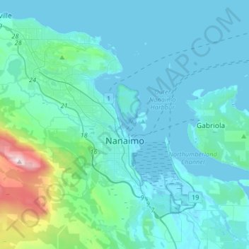
Name: Nanaimo topographic map, elevation, terrain.
Average elevation: 361 ft
Minimum elevation: -7 ft
Maximum elevation: 3,294 ft
Other topographic maps
Click on a map to view its topography, its elevation and its terrain.
Cedar
Canada > British Columbia > Regional District of Nanaimo > Area A (Cassidy/Cedar)
Cedar, Area A (Cassidy/Cedar), Regional District of Nanaimo, British Columbia, V9X 1L9, Canada
Average elevation: 89 ft
Parksville
Canada > British Columbia > Regional District of Nanaimo > Parksville
Parksville, Regional District of Nanaimo, British Columbia, Canada
Average elevation: 125 ft