
Darwin topographic map
Interactive map
Click on the map to display elevation.
About this map
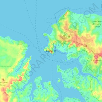
Name: Darwin topographic map, elevation, terrain.
Average elevation: 26 ft
Minimum elevation: -10 ft
Maximum elevation: 167 ft
Other topographic maps
Click on a map to view its topography, its elevation and its terrain.
Nightcliff
Australia > City of Darwin > Darwin
Nightcliff, Darwin, City of Darwin, Northern Territory, 0800, Australia
Average elevation: 30 ft
Wulagi
Australia > City of Darwin > Darwin
Wulagi, Darwin, City of Darwin, Northern Territory, 0800, Australia
Average elevation: 89 ft