
Areguá topographic map
Interactive map
Click on the map to display elevation.
About this map
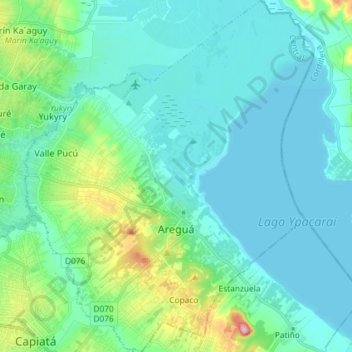
Name: Areguá topographic map, elevation, terrain.
Location: Areguá, Central Department, Región Oriental, Paraguay (-25.35888 -57.44770 -25.22742 -57.32782)
Average elevation: 292 ft
Minimum elevation: 190 ft
Maximum elevation: 791 ft
Areguá is thought to come from Classical Guarani ariguâ·r ("[person/people] from above, from up there"), refererring to the area's high altitude and its first inhabitants from the Mbya Guarani tribes.
Other topographic maps
Click on a map to view its topography, its elevation and its terrain.
District of Itauguá
District of Itauguá, Central Department, Región Oriental, Paraguay
Average elevation: 397 ft
Laguna Grande
Paraguay > Central Department > Fernando de la Mora
Laguna Grande, Fernando de la Mora, Central Department, Región Oriental, Paraguay
Average elevation: 466 ft
San José
Paraguay > Central Department > Villa Elisa
San José, Villa Elisa, Central Department, Región Oriental, Paraguay
Average elevation: 463 ft
Mariano Roque Alonso
Mariano Roque Alonso, Central Department, Región Oriental, Paraguay
Average elevation: 243 ft
Primer Barrio
Paraguay > Central Department > Luque
Primer Barrio, Luque, Central Department, Región Oriental, Paraguay
Average elevation: 361 ft
Palomar
Paraguay > Central Department > Lambaré
Palomar, Lambaré, Central Department, Región Oriental, 110701, Paraguay
Average elevation: 430 ft
Caaguazú
Paraguay > Central Department > Ñemby
Caaguazú, Ñemby, Central Department, Región Oriental, Paraguay
Average elevation: 449 ft
Villeta
Villeta, Central Department, Región Oriental, Paraguay
Average elevation: 233 ft
San Lorenzo
San Lorenzo, Central Department, Región Oriental, Paraguay
Average elevation: 440 ft
Fernando de la Mora
Fernando de la Mora, Central Department, Región Oriental, Paraguay
Average elevation: 472 ft
Luque
Luque, Central Department, Región Oriental, Paraguay
Average elevation: 331 ft