
Fayetteville topographic map
Interactive map
Click on the map to display elevation.
About this map
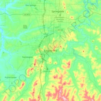
Name: Fayetteville topographic map, elevation, terrain.
Average elevation: 1,325 ft
Minimum elevation: 1,017 ft
Maximum elevation: 2,211 ft
...yet I venture the assertion that nowhere in said country—or for that matter, in any part of the state—could be found a lovelier elevation, or a lovelier grove of graceful oaks, or a more commanding view, or, in fine, a spot better suited and adapted for the purposes designated than the one chosen for said University site and farm.
Other topographic maps
Click on a map to view its topography, its elevation and its terrain.
South Mountain
United States > Arkansas > Washington County > Fayetteville
South Mountain, Fayetteville, Washington County, Arkansas, 72701, United States
Average elevation: 1,329 ft
Washington Mountain
United States > Arkansas > Washington County > Fayetteville
Washington Mountain, Fayetteville, Washington County, Arkansas, United States
Average elevation: 1,342 ft