
Murfreesboro topographic map
Interactive map
Click on the map to display elevation.
About this map
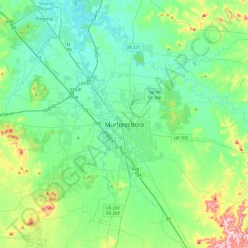
Name: Murfreesboro topographic map, elevation, terrain.
Average elevation: 676 ft
Minimum elevation: 486 ft
Maximum elevation: 1,358 ft
Other topographic maps
Click on a map to view its topography, its elevation and its terrain.
Oak Hill
United States > Tennessee > Rutherford County > Murfreesboro
Oak Hill, Murfreesboro, Rutherford County, Middle Tennessee, Tennessee, 37130, United States
Average elevation: 604 ft
Georgetown
United States > Tennessee > Rutherford County > Murfreesboro
Georgetown, Murfreesboro, Rutherford County, Middle Tennessee, Tennessee, 37129, United States
Average elevation: 577 ft
Northpointe Hall
United States > Tennessee > Rutherford County > Murfreesboro > Northpointe Hall
Northpointe Hall, Murfreesboro, Rutherford County, Tennessee, 37129, United States
Average elevation: 587 ft
Brookhill
United States > Tennessee > Rutherford County > Murfreesboro > Brookhill
Brookhill, Murfreesboro, Rutherford County, Tennessee, 37128, United States
Average elevation: 610 ft
Lascassas Villa
United States > Tennessee > Rutherford County > Murfreesboro > Lascassas Villa
Lascassas Villa, Murfreesboro, Rutherford County, Tennessee, 37130, United States
Average elevation: 614 ft