
Franklin topographic map
Interactive map
Click on the map to display elevation.
About this map
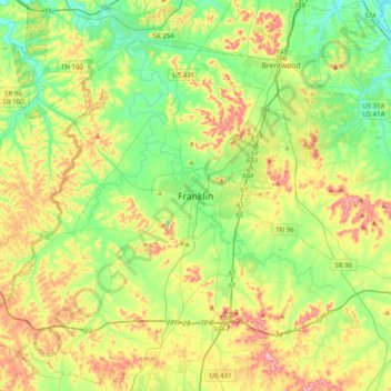
Name: Franklin topographic map, elevation, terrain.
Location: Franklin, Williamson County, Tennessee, 36711, United States (35.76521 -87.02894 36.08521 -86.70894)
Average elevation: 758 ft
Minimum elevation: 486 ft
Maximum elevation: 1,237 ft
Other topographic maps
Click on a map to view its topography, its elevation and its terrain.
Jim Warren Park
United States > Tennessee > Williamson County > Franklin > Westfield Estates
Jim Warren Park, Westfield Estates, Franklin, Williamson County, Middle Tennessee, Tennessee, United States
Average elevation: 679 ft
Hill Estates
United States > Tennessee > Williamson County > Franklin
Hill Estates, Franklin, Williamson County, Tennessee, 36711, United States
Average elevation: 686 ft