
Doylestown topographic map
Interactive map
Click on the map to display elevation.
About this map
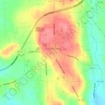
Name: Doylestown topographic map, elevation, terrain.
Location: Doylestown, Wayne County, Ohio, 44230, United States (40.95314 -81.71152 40.98445 -81.67797)
Average elevation: 1,158 ft
Minimum elevation: 1,017 ft
Maximum elevation: 1,296 ft
A handful of small streams begin at springs on the slopes of the hill and flow from the higher elevations into larger creeks surrounding the village. Silver Creek drains the town on the east, Mill Creek on the north and west, while Chippewa Creek drains the south side and collects both Mill and Silver Creeks. Where Silver Creek flows into Chippewa Creek just southeast of town, in Rogues' Hollow, the elevation is 950 feet.
Other topographic maps
Click on a map to view its topography, its elevation and its terrain.
Chester Township
United States > Ohio > Wayne County
Chester Township, Wayne County, Ohio, United States
Average elevation: 1,115 ft
Burbank
United States > Ohio > Wayne County
Burbank, Canaan Township, Wayne County, Ohio, United States
Average elevation: 994 ft
Creston
United States > Ohio > Wayne County
Creston, Wayne County, Ohio, United States
Average elevation: 991 ft
Smithville
United States > Ohio > Wayne County
Smithville, Wayne County, Ohio, 44677, United States
Average elevation: 1,093 ft
West Salem
United States > Ohio > Wayne County
West Salem, Congress Township, Wayne County, Ohio, United States
Average elevation: 1,102 ft
Wooster
United States > Ohio > Wayne County
Wooster, Wayne County, Ohio, 44691, United States
Average elevation: 1,033 ft
Kidron
United States > Ohio > Wayne County
Kidron, Wayne County, Ohio, 44636, United States
Average elevation: 1,178 ft
Orrville
United States > Ohio > Wayne County
Orrville, Wayne County, Ohio, 44667, United States
Average elevation: 1,060 ft
Munson Knob
United States > Ohio > Wayne County
Munson Knob, Wayne County, Ohio, 44633, United States
Average elevation: 1,070 ft
Marshallville
United States > Ohio > Wayne County
Marshallville, Wayne County, Ohio, United States
Average elevation: 1,099 ft
Fredericksburg
United States > Ohio > Wayne County > Fredericksburg
Fredericksburg, Wayne County, Ohio, United States
Average elevation: 1,063 ft
Dalton
United States > Ohio > Wayne County
Dalton, Wayne County, Ohio, United States
Average elevation: 1,119 ft
Rittman
United States > Ohio > Wayne County
Rittman, Wayne County, Ohio, United States
Average elevation: 1,024 ft
Canaan
United States > Ohio > Wayne County > Canaan
Canaan, Canaan Township, Wayne County, Ohio, 44217, United States
Average elevation: 1,093 ft