
Bradenton topographic map
Interactive map
Click on the map to display elevation.
About this map
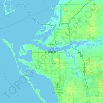
Name: Bradenton topographic map, elevation, terrain.
Location: Bradenton, Manatee County, Florida, 34205, United States (27.33893 -82.73482 27.65893 -82.41482)
Average elevation: 16 ft
Minimum elevation: -13 ft
Maximum elevation: 118 ft
Other topographic maps
Click on a map to view its topography, its elevation and its terrain.
Manatee
United States > Florida > Manatee County > Bradenton
Manatee, Bradenton, Manatee County, Florida, 34208, United States
Average elevation: 13 ft
Palma Sola Bay
United States > Florida > Manatee County > Bradenton
Palma Sola Bay, Bradenton, Manatee County, Florida, United States
Average elevation: 7 ft