
Corinth topographic map
Interactive map
Click on the map to display elevation.
About this map
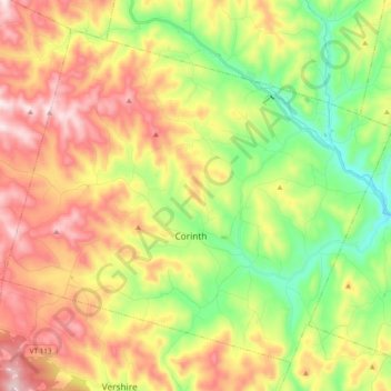
Name: Corinth topographic map, elevation, terrain.
Location: Corinth, Orange County, Vermont, 05039, United States (43.97938 -72.38183 44.09626 -72.19157)
Average elevation: 1,345 ft
Minimum elevation: 594 ft
Maximum elevation: 2,244 ft
Other topographic maps
Click on a map to view its topography, its elevation and its terrain.
East Corinth
United States > Vermont > Orange County > Corinth
East Corinth, Corinth, Orange County, Vermont, 05040, United States
Average elevation: 958 ft