
Kyger topographic map
Interactive map
Click on the map to display elevation.
About this map
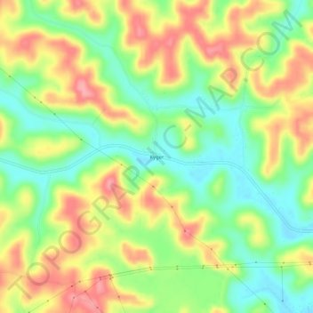
Name: Kyger topographic map, elevation, terrain.
Average elevation: 722 ft
Minimum elevation: 568 ft
Maximum elevation: 896 ft
Other topographic maps
Click on a map to view its topography, its elevation and its terrain.
Gallia County Fairgrounds
United States > Ohio > Gallia County
Gallia County Fairgrounds, Springfield Township, Gallia County, Ohio, 45631, United States
Average elevation: 656 ft
Evergreen
United States > Ohio > Gallia County
Evergreen, Springfield Township, Gallia County, Ohio, 45614, United States
Average elevation: 719 ft
Northup
United States > Ohio > Gallia County
Northup, Green Township, Gallia County, Ohio, United States
Average elevation: 669 ft
Centerville
United States > Ohio > Gallia County
Centerville, Gallia County, Ohio, United States
Average elevation: 725 ft
Rio Grande
United States > Ohio > Gallia County
Rio Grande, Gallia County, Ohio, United States
Average elevation: 686 ft
Harrisburg
United States > Ohio > Gallia County
Harrisburg, Raccoon Township, Gallia County, Ohio, 45674, United States
Average elevation: 673 ft
Mercerville
United States > Ohio > Gallia County
Mercerville, Guyan Township, Gallia County, Ohio, 45623, United States
Average elevation: 804 ft
Porter
United States > Ohio > Gallia County
Porter, Springfield Township, Gallia County, Ohio, 45614, United States
Average elevation: 728 ft
Bidwell
United States > Ohio > Gallia County
Bidwell, Springfield Township, Gallia County, Ohio, 45614, United States
Average elevation: 709 ft
Adamsville
United States > Ohio > Gallia County
Adamsville, Raccoon Township, Gallia County, Ohio, 45674, United States
Average elevation: 666 ft
Ewington
United States > Ohio > Gallia County
Ewington, Huntington Township, Gallia County, Ohio, 45686, United States
Average elevation: 689 ft
Rodney
United States > Ohio > Gallia County
Rodney, Green Township, Gallia County, Ohio, United States
Average elevation: 705 ft
Kanauga
United States > Ohio > Gallia County
Kanauga, Gallipolis Township, Gallia County, Ohio, 25106, United States
Average elevation: 614 ft
Centerpoint
United States > Ohio > Gallia County
Centerpoint, Perry Township, Gallia County, Ohio, United States
Average elevation: 771 ft
Gallia
United States > Ohio > Gallia County
Gallia, Greenfield Township, Gallia County, Ohio, United States
Average elevation: 735 ft
Kerr
United States > Ohio > Gallia County
Kerr, Springfield Township, Gallia County, Ohio, 45614, United States
Average elevation: 673 ft
Springfield Township
United States > Ohio > Gallia County
Springfield Township, Gallia County, Ohio, 45614, United States
Average elevation: 705 ft
Vinton
United States > Ohio > Gallia County
Vinton, Gallia County, Ohio, 45686, United States
Average elevation: 679 ft
Patriot
United States > Ohio > Gallia County
Patriot, Perry Township, Gallia County, Ohio, 45658, United States
Average elevation: 738 ft
Cheshire
United States > Ohio > Gallia County
Cheshire, Gallia County, Ohio, United States
Average elevation: 591 ft
Gallipolis
United States > Ohio > Gallia County
Gallipolis, Gallia County, Ohio, United States
Average elevation: 666 ft
Crown City
United States > Ohio > Gallia County
Crown City, Gallia County, Ohio, United States
Average elevation: 663 ft
Bulaville
United States > Ohio > Gallia County
Bulaville, Addison Township, Gallia County, Ohio, United States
Average elevation: 676 ft