
Watertown topographic map
Interactive map
Click on the map to display elevation.
About this map
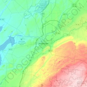
Name: Watertown topographic map, elevation, terrain.
Average elevation: 643 ft
Minimum elevation: 236 ft
Maximum elevation: 1,624 ft
Watertown is around 60 miles (97 kilometers) northwest of Syracuse, 20 miles (32 kilometers) south of the Thousand Islands and 328 miles (530 kilometers) northwest of New York City. According to the United States Census Bureau, the city has a total area of 9.3 square miles (24 km2), of which 9.0 square miles (23 km2) are land and 0.3 square miles (0.78 km2) (3.45 percent) is water. Before the area was settled, all the land was rough and forested. Elevation was also a problem. The Black River, flowing westward through the city toward Lake Ontario, is a world-renowned kayaking destination. Competition-level kayaking events, such as the Blackwater Challenge, have been held on the river.
Other topographic maps
Click on a map to view its topography, its elevation and its terrain.
Village of Antwerp
United States > New York > Jefferson County > Town of Antwerp
Village of Antwerp, Town of Antwerp, Jefferson County, New York, United States
Average elevation: 525 ft
Town of Hounsfield
United States > New York > Jefferson County
Town of Hounsfield, Jefferson County, New York, 13685, United States
Average elevation: 492 ft
Beebee's Island
United States > New York > Jefferson County > City of Watertown
Beebee's Island, City of Watertown, Jefferson County, New York, 13601, United States
Average elevation: 669 ft
Village of Dexter
United States > New York > Jefferson County > Town of Brownville
Village of Dexter, Town of Brownville, Jefferson County, New York, United States
Average elevation: 315 ft
Village of Sackets Harbor
United States > New York > Jefferson County
Village of Sackets Harbor, Town of Hounsfield, Jefferson County, New York, 13685, United States
Average elevation: 269 ft
Village of West Carthage
United States > New York > Jefferson County
Village of West Carthage, Town of Champion, Jefferson County, New York, United States
Average elevation: 758 ft
Village of Philadelphia
United States > New York > Jefferson County
Village of Philadelphia, Town of Philadelphia, Jefferson County, New York, 13673, United States
Average elevation: 489 ft
Bayview
United States > New York > Jefferson County
Bayview, Town of Lyme, Jefferson County, New York, 13693, United States
Average elevation: 266 ft
Murray Isle
United States > New York > Jefferson County > Town of Clayton > Grenell
Murray Isle, Grenell, Town of Clayton, Jefferson County, New York, United States
Average elevation: 256 ft
Butterfield Lake
United States > New York > Jefferson County > Town of Theresa > Redwood
Butterfield Lake, Redwood, Town of Theresa, Town of Alexandria, Jefferson County, New York, United States
Average elevation: 325 ft
Village of Carthage
United States > New York > Jefferson County
Village of Carthage, Town of Wilna, Jefferson County, New York, 13619, United States
Average elevation: 748 ft
Fort Drum
United States > New York > Jefferson County
Fort Drum, Town of Le Ray, Jefferson County, New York, United States
Average elevation: 571 ft
Town of Theresa
United States > New York > Jefferson County
Town of Theresa, Jefferson County, New York, 13691, United States
Average elevation: 394 ft
Town of Adams
United States > New York > Jefferson County
Town of Adams, Jefferson County, New York, United States
Average elevation: 597 ft
Village of Black River
United States > New York > Jefferson County
Village of Black River, Town of Le Ray, Jefferson County, New York, United States
Average elevation: 633 ft
Village of Brownville
United States > New York > Jefferson County > Town of Brownville
Village of Brownville, Town of Brownville, Jefferson County, New York, 13615, United States
Average elevation: 361 ft
Village of Theresa
United States > New York > Jefferson County > Town of Theresa
Village of Theresa, Town of Theresa, Jefferson County, New York, 13691, United States
Average elevation: 397 ft
Henderson
United States > New York > Jefferson County > Henderson
Henderson, Jefferson County, New York, United States
Average elevation: 331 ft
Warren
United States > New York > Jefferson County > Warren
Warren, Cape Vincent, Jefferson County, New York, United States
Average elevation: 325 ft
Adams Center
United States > New York > Jefferson County > Adams Center
Adams Center, Town of Adams, Jefferson County, New York, 13606, United States
Average elevation: 636 ft
Cape Vincent
United States > New York > Jefferson County > Cape Vincent
Cape Vincent, Jefferson County, New York, United States
Average elevation: 276 ft
City of Watertown
United States > New York > Jefferson County
City of Watertown, Jefferson County, New York, 13601, United States
Average elevation: 492 ft
Calcium
United States > New York > Jefferson County
Calcium, Town of Le Ray, Jefferson County, New York, 13616, United States
Average elevation: 505 ft
Holiday Island
United States > New York > Jefferson County
Holiday Island, Town of Orleans, Jefferson County, New York, 13640, United States
Average elevation: 371 ft