
Torrance topographic map
Interactive map
Click on the map to display elevation.
About this map
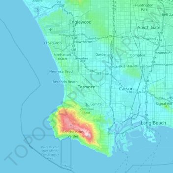
Name: Torrance topographic map, elevation, terrain.
Average elevation: 82 ft
Minimum elevation: -10 ft
Maximum elevation: 1,480 ft
Other topographic maps
Click on a map to view its topography, its elevation and its terrain.
Dudmore
United States > California > Los Angeles County > Torrance
Dudmore, Torrance, Los Angeles County, California, 90503, United States
Average elevation: 95 ft
Bridgedale
United States > California > Los Angeles County > Torrance
Bridgedale, Torrance, Los Angeles County, California, 90506, United States
Average elevation: 62 ft
Hollywood Riviera
United States > California > Los Angeles County > Torrance > Hollywood Riviera
Hollywood Riviera, Torrance, Los Angeles County, California, 90277, United States
Average elevation: 164 ft
Rat Beach
United States > California > Los Angeles County > Torrance
Rat Beach, Palos Verdes Estates, Torrance, Los Angeles County, California, United States
Average elevation: 230 ft