
Flin Flon topographic map
Interactive map
Click on the map to display elevation.
About this map
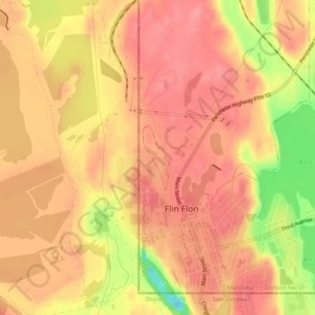
Name: Flin Flon topographic map, elevation, terrain.
Location: Flin Flon, Manitoba, Canada (54.77136 -101.88466 54.77693 -101.88076)
Average elevation: 1,070 ft
Minimum elevation: 856 ft
Maximum elevation: 1,155 ft
Other topographic maps
Click on a map to view its topography, its elevation and its terrain.
Embury Lake
Embury Lake, Snoman Trail, Flin Flon, Manitoba, R8A, Canada
Average elevation: 1,027 ft