
Goose Creek topographic map
Interactive map
Click on the map to display elevation.
About this map
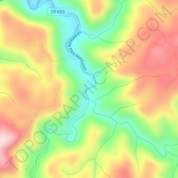
Name: Goose Creek topographic map, elevation, terrain.
Location: Goose Creek, Floyd County, Virginia, 24072, United States (37.08258 -80.20599 37.08579 -80.20404)
Average elevation: 2,136 ft
Minimum elevation: 1,594 ft
Maximum elevation: 2,684 ft
Other topographic maps
Click on a map to view its topography, its elevation and its terrain.
Indian Valley
United States > Virginia > Floyd County
Indian Valley, Floyd County, Virginia, 24105, United States
Average elevation: 2,608 ft
Chestnut Creek Wetlands State Natural Area Preserve
United States > Virginia > Floyd County
Chestnut Creek Wetlands State Natural Area Preserve, Floyd County, Virginia, United States
Average elevation: 2,953 ft
Willis
United States > Virginia > Floyd County
Willis, Floyd County, Virginia, 24380, United States
Average elevation: 2,861 ft
Floyd
United States > Virginia > Floyd County > Floyd
Floyd, Floyd County, Virginia, United States
Average elevation: 2,444 ft
Check
United States > Virginia > Floyd County
Check, Floyd County, Virginia, 24079, United States
Average elevation: 2,635 ft
Haycock
United States > Virginia > Floyd County
Haycock, Floyd County, Virginia, United States
Average elevation: 2,608 ft