
Carleton-sur-Mer topographic map
Interactive map
Click on the map to display elevation.
About this map
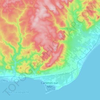
Name: Carleton-sur-Mer topographic map, elevation, terrain.
Average elevation: 682 ft
Minimum elevation: -3 ft
Maximum elevation: 2,136 ft
Other topographic maps
Click on a map to view its topography, its elevation and its terrain.
Mont Carleton
Canada > Quebec > Avignon > Carleton-sur-Mer
Mont Carleton, Carleton-sur-Mer, Avignon, Gaspésie–Îles-de-la-Madeleine, Quebec, Canada
Average elevation: 1,535 ft
Cross Point Station
Canada > Quebec > Avignon > Pointe-à-la-Croix > Cross Point Station
Cross Point Station, Pointe-à-la-Croix, Avignon, Gaspésie–Îles-de-la-Madeleine, Quebec, G0C 1L0, Canada
Average elevation: 190 ft
Pointe-à-la-Croix
Pointe-à-la-Croix, Avignon, Gaspésie–Îles-de-la-Madeleine, Quebec, G0C 1L0, Canada
Average elevation: 761 ft