
Chula Vista topographic map
Interactive map
Click on the map to display elevation.
About this map
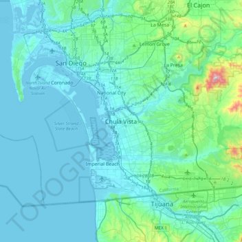
Name: Chula Vista topographic map, elevation, terrain.
Average elevation: 266 ft
Minimum elevation: -36 ft
Maximum elevation: 2,503 ft
Other topographic maps
Click on a map to view its topography, its elevation and its terrain.
Castle Park
United States > California > San Diego County > Chula Vista
Castle Park, Chula Vista, San Diego County, California, 91911, United States
Average elevation: 112 ft