
Seeley topographic map
Interactive map
Click on the map to display elevation.
About this map
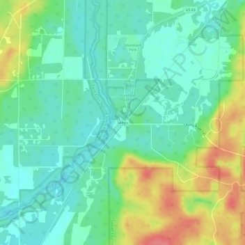
Name: Seeley topographic map, elevation, terrain.
Average elevation: 1,309 ft
Minimum elevation: 1,230 ft
Maximum elevation: 1,470 ft
Other topographic maps
Click on a map to view its topography, its elevation and its terrain.
Little Round Lake
United States > Wisconsin > Sawyer County
Little Round Lake, Town of Bass Lake, Sawyer County, Wisconsin, United States
Average elevation: 1,348 ft
Winter
United States > Wisconsin > Sawyer County
Winter, Sawyer County, Wisconsin, United States
Average elevation: 1,355 ft
Hayward
United States > Wisconsin > Sawyer County
Hayward, Sawyer County, Wisconsin, United States
Average elevation: 1,204 ft
Exeland
United States > Wisconsin > Sawyer County > Exeland
Exeland, Sawyer County, Wisconsin, United States
Average elevation: 1,207 ft