
Kurseong topographic map
Interactive map
Click on the map to display elevation.
About this map
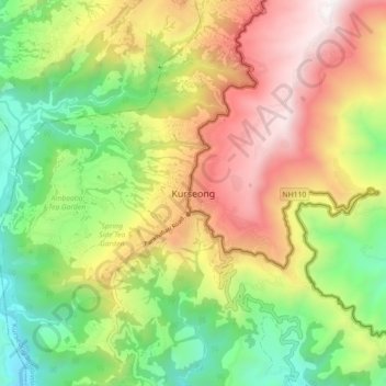
Name: Kurseong topographic map, elevation, terrain.
Average elevation: 3,698 ft
Minimum elevation: 1,129 ft
Maximum elevation: 6,929 ft
Located at an altitude of 1,482.55 metres (4,864.0 ft), Kurseong is 32 kilometres (20 mi) from Darjeeling and has a pleasant climate throughout the year.
Other topographic maps
Click on a map to view its topography, its elevation and its terrain.
Sittong, West Bengal
India > West Bengal > Kurseong Subdivision
Sittong, West Bengal, Kurseong Subdivision, Darjeeling district, West Bengal, India
Average elevation: 1,529 ft