
Holywell topographic map
Interactive map
Click on the map to display elevation.
About this map
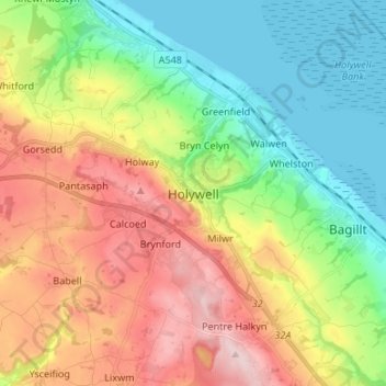
Name: Holywell topographic map, elevation, terrain.
Location: Holywell, Flintshire, Wales, CH8 7UR, United Kingdom (53.23141 -3.26130 53.31141 -3.18130)
Average elevation: 390 ft
Minimum elevation: 0 ft
Maximum elevation: 958 ft
Other topographic maps
Click on a map to view its topography, its elevation and its terrain.
Mold
United Kingdom > Wales > Flintshire
Mold, Flintshire, Wales, CH7 1ER, United Kingdom
Average elevation: 541 ft
Connah's Quay
United Kingdom > Wales > Flintshire
Connah's Quay, Flintshire, Wales, CH5 4AL, United Kingdom
Average elevation: 138 ft
Drury
United Kingdom > Wales > Flintshire
Drury, Flintshire, Wales, CH7 3EA, United Kingdom
Average elevation: 377 ft
Axton
United Kingdom > Wales > Flintshire > Trelogan
Axton, Llanasa, Trelogan, Flintshire, Wales, CH8 9DJ, United Kingdom
Average elevation: 551 ft