
Wrocław topographic map
Interactive map
Click on the map to display elevation.
About this map
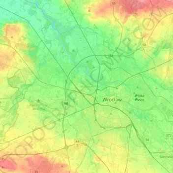
Name: Wrocław topographic map, elevation, terrain.
Location: Wrocław, Trzebnica County, Lower Silesian Voivodeship, Poland (51.04267 16.80734 51.21006 17.17622)
Average elevation: 410 ft
Minimum elevation: 325 ft
Maximum elevation: 558 ft
Other topographic maps
Click on a map to view its topography, its elevation and its terrain.
Sienna
Poland > Lower Silesian Voivodeship > Trzebnica County > Rościsławice
Sienna, Rościsławice, gmina Oborniki Śląskie, Trzebnica County, Lower Silesian Voivodeship, Poland
Average elevation: 528 ft
Trzebnica
Poland > Lower Silesian Voivodeship > Trzebnica County
Trzebnica, gmina Trzebnica, Trzebnica County, Lower Silesian Voivodeship, 55-100, Poland
Average elevation: 640 ft