
Södertälje topographic map
Interactive map
Click on the map to display elevation.
About this map
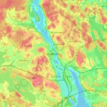
Name: Södertälje topographic map, elevation, terrain.
Average elevation: 125 ft
Minimum elevation: -20 ft
Maximum elevation: 266 ft
Due to its topography and the fact that it is divided by a canal, it has been difficult to build good train connections in and through the city. Despite this, Södertälje is one of the largest railway hubs in Sweden. When the railway to Södertälje was commissioned, it was decided that the main line would not be drawn through what was then the immediate city centre. The decision was one of the factors behind the urban planning of the area Mariekälla, just south of the Järnatullen city toll.
Other topographic maps
Click on a map to view its topography, its elevation and its terrain.
Norrtälje kommun
Norrtälje kommun, Stockholm County, Sweden
Average elevation: 43 ft
Nykvarns kommun
Nykvarns kommun, Stockholm County, Sweden
Average elevation: 135 ft
Kungsängen
Kungsängen, Upplands-Bro kommun, Stockholm County, 196 40, Sweden
Average elevation: 66 ft
Stockholm
Stockholm, Stockholms kommun, Stockholm County, 111 29, Sweden
Average elevation: 85 ft
Gustavsberg
Gustavsberg, Värmdö kommun, Stockholm County, Sweden
Average elevation: 56 ft
Ekeby
Ekeby, Södertälje kommun, Stockholm County, Sweden
Average elevation: 131 ft
Sigtuna kommun
Sigtuna kommun, Stockholm County, Sweden
Average elevation: 85 ft
Södertälje kommun
Södertälje kommun, Stockholm County, Sweden
Average elevation: 102 ft
Upplands-Bro kommun
Upplands-Bro kommun, Stockholm County, Sweden
Average elevation: 62 ft
Boo
Boo, Nacka kommun, Stockholm County, 132 30, Sweden
Average elevation: 75 ft
Stockholm
Stockholm, Solna kommun, Stockholm County, Sweden
Average elevation: 82 ft
Hölö
Hölö, Södertälje kommun, Stockholm County, 153 71, Sweden
Average elevation: 112 ft
Värmdö kommun
Värmdö kommun, Stockholm County, Sweden
Average elevation: 30 ft
Haninge kommun
Haninge kommun, Stockholm County, Sweden
Average elevation: 30 ft