
Nashville topographic map
Interactive map
Click on the map to display elevation.
About this map
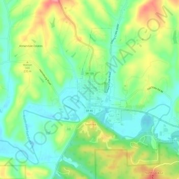
Name: Nashville topographic map, elevation, terrain.
Location: Nashville, Brown County, Indiana, United States (39.19162 -86.25095 39.22205 -86.19358)
Average elevation: 682 ft
Minimum elevation: 564 ft
Maximum elevation: 876 ft
Other topographic maps
Click on a map to view its topography, its elevation and its terrain.
Helmsburg
United States > Indiana > Brown County
Helmsburg, Brown County, Indiana, 47435, United States
Average elevation: 728 ft
Needmore
United States > Indiana > Brown County
Needmore, Brown County, Indiana, 47435, United States
Average elevation: 732 ft
Becks Grove
United States > Indiana > Brown County
Becks Grove, Brown County, Indiana, United States
Average elevation: 784 ft
Christiansburg
United States > Indiana > Brown County
Christiansburg, Brown County, Indiana, United States
Average elevation: 712 ft
Fruitdale
United States > Indiana > Brown County
Fruitdale, Brown County, Indiana, 46160, United States
Average elevation: 810 ft
Pikes Peak
United States > Indiana > Brown County
Pikes Peak, Brown County, Indiana, United States
Average elevation: 719 ft
Camp Roberts
United States > Indiana > Brown County
Camp Roberts, Brown County, Indiana, United States
Average elevation: 741 ft
Cornelius
United States > Indiana > Brown County
Cornelius, Brown County, Indiana, 47435, United States
Average elevation: 794 ft
Clarksdale
United States > Indiana > Brown County
Clarksdale, Brown County, Indiana, United States
Average elevation: 794 ft
Mount Liberty
United States > Indiana > Brown County
Mount Liberty, Brown County, Indiana, United States
Average elevation: 791 ft
Lanam
United States > Indiana > Brown County
Lanam, Brown County, Indiana, 47435, United States
Average elevation: 794 ft
Belmont
United States > Indiana > Brown County
Belmont, Brown County, Indiana, United States
Average elevation: 643 ft
Elkinsville
United States > Indiana > Brown County
Elkinsville, Brown County, Indiana, United States
Average elevation: 656 ft
Gatesville
United States > Indiana > Brown County
Gatesville, Brown County, Indiana, United States
Average elevation: 781 ft
Peoga
United States > Indiana > Brown County
Peoga, Brown County, Indiana, 46164, United States
Average elevation: 919 ft
Gnaw Bone
United States > Indiana > Brown County
Gnaw Bone, Brown County, Indiana, United States
Average elevation: 758 ft
Stone Head
United States > Indiana > Brown County
Stone Head, Brown County, Indiana, United States
Average elevation: 702 ft
Spearsville
United States > Indiana > Brown County
Spearsville, Brown County, Indiana, United States
Average elevation: 889 ft
Kirkofer Lake Dam
United States > Indiana > Brown County
Kirkofer Lake Dam, Brown County, Indiana, United States
Average elevation: 791 ft
Trevlac
United States > Indiana > Brown County
Trevlac, Brown County, Indiana, 47435, United States
Average elevation: 702 ft
Taggart
United States > Indiana > Brown County
Taggart, Brown County, Indiana, United States
Average elevation: 778 ft
Story
United States > Indiana > Brown County
Story, Brown County, Indiana, United States
Average elevation: 640 ft
Beanblossom
United States > Indiana > Brown County
Beanblossom, Brown County, Indiana, 47435, United States
Average elevation: 764 ft