
Tuam topographic map
Interactive map
Click on the map to display elevation.
About this map
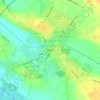
Name: Tuam topographic map, elevation, terrain.
Average elevation: 131 ft
Minimum elevation: 89 ft
Maximum elevation: 180 ft
Other topographic maps
Click on a map to view its topography, its elevation and its terrain.
Furbo
Furbo, County Galway, Connacht, H91 KX27, Ireland
Average elevation: 52 ft
Headford
Headford, Headford ED, Tuam Municipal District, County Galway, Connacht, Ireland
Average elevation: 66 ft
Curtaun
Curtaun, Beagh ED, Loughrea Municipal District, County Galway, Connacht, Ireland
Average elevation: 89 ft
Gurteen
Gurteen, Cappalusk ED, Athenry-Oranmore Municipal District, County Galway, Connacht, Ireland
Average elevation: 292 ft
Glassilaun Beach
Glassilaun Beach, Cushkillary ED, Conamara Municipal District, County Galway, Connacht, Ireland
Average elevation: 36 ft
Eyrephort
Eyrephort, Clifden ED, Conamara Municipal District, County Galway, Connacht, Ireland
Average elevation: 20 ft
Mullaghmore East
Mullaghmore East, Cooloo ED, Ballinasloe Municipal District, County Galway, Connacht, Ireland
Average elevation: 259 ft
Loughrea Municipal District
Loughrea Municipal District, County Galway, Connacht, Ireland
Average elevation: 226 ft
Kilconnell
Kilconnell, Kilconnell ED, Ballinasloe Municipal District, County Galway, Connacht, Ireland
Average elevation: 302 ft
Cappataggle
Cappataggle, Killallaghtan ED, Ballinasloe Municipal District, County Galway, Connacht, Ireland
Average elevation: 400 ft
Kiltullagh North
Kiltullagh North, Kiltullagh ED, Loughrea Municipal District, County Galway, Connacht, Ireland
Average elevation: 151 ft
Cappaghnagapple
Cappaghnagapple, Cloonbur ED, Conamara Municipal District, County Galway, Connacht, Ireland
Average elevation: 236 ft
Claregalway
Claregalway, Athenry-Oranmore Municipal District, County Galway, Connacht, H91 F5EH, Ireland
Average elevation: 52 ft
Derryclare
Derryclare, Conamara Municipal District, County Galway, Connacht, H91 TP63, Ireland
Average elevation: 915 ft
Ballinasloe Municipal District
Ballinasloe Municipal District, County Galway, Connacht, Ireland
Average elevation: 217 ft
Ballybrit
Ireland > County Galway > Galway
Ballybrit, Galway, County Galway, Connacht, Ireland
Average elevation: 128 ft
Carrowroe South
Carrowroe South, An Crompán, Conamara Municipal District, County Galway, Connacht, Ireland
Average elevation: 36 ft
Killeany
Killeany, Inishmore, Conamara Municipal District, County Galway, Connacht, H91 P266, Ireland
Average elevation: 75 ft
Gortnarup
Gortnarup, Cloonbur ED, Conamara Municipal District, County Galway, Connacht, Ireland
Average elevation: 374 ft
Athenry-Oranmore Municipal District
Athenry-Oranmore Municipal District, County Galway, Connacht, Ireland
Average elevation: 138 ft
Carrowroe
Carrowroe, Kilmeen ED, Loughrea Municipal District, County Galway, Connacht, Ireland
Average elevation: 249 ft
Fairhill
Fairhill, Mounthazel ED, Ballinasloe Municipal District, County Galway, Connacht, Ireland
Average elevation: 285 ft
Galway Bay
Galway Bay, County Galway, Connacht, Ireland
Average elevation: 115 ft
Newforest
Newforest, Curraghmore ED, Ballinasloe Municipal District, County Galway, Connacht, Ireland
Average elevation: 269 ft
Kylemore
Kylemore, Loughrea Municipal District, County Galway, Connacht, Ireland
Average elevation: 148 ft
Capira
Capira, Portumna ED, Loughrea Municipal District, County Galway, Connacht, Ireland
Average elevation: 174 ft