
Independence topographic map
Interactive map
Click on the map to display elevation.
About this map
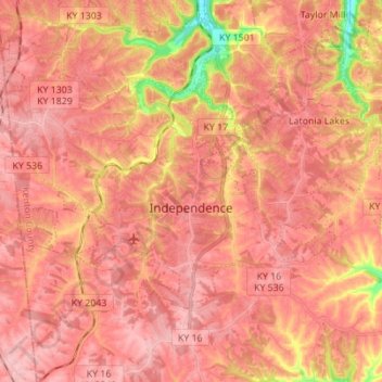
Name: Independence topographic map, elevation, terrain.
Location: Independence, Kenton County, Kentucky, 41051, United States (38.91455 -84.61135 38.98071 -84.47311)
Average elevation: 833 ft
Minimum elevation: 499 ft
Maximum elevation: 961 ft
Other topographic maps
Click on a map to view its topography, its elevation and its terrain.
Fort Wright
United States > Kentucky > Kenton County
Fort Wright, Kenton County, Kentucky, United States
Average elevation: 719 ft
Pride Park
United States > Kentucky > Kenton County > Taylor Mill
Pride Park, Taylor Mill, Kenton County, Kentucky, United States
Average elevation: 778 ft
Piner
United States > Kentucky > Kenton County
Piner, Kenton County, Kentucky, 41163, United States
Average elevation: 823 ft
Covington
United States > Kentucky > Kenton County
Covington, Kenton County, Kentucky, United States
Average elevation: 705 ft
Erlanger
United States > Kentucky > Kenton County
Erlanger, Kenton County, Kentucky, 41018, United States
Average elevation: 846 ft
Daniel Carter Beard Boyhood Home
United States > Kentucky > Kenton County > Covington
Daniel Carter Beard Boyhood Home, Licking Riverside Historic District, Covington, Kenton County, Kentucky, United States
Average elevation: 515 ft
Taylor Mill
United States > Kentucky > Kenton County
Taylor Mill, Kenton County, Kentucky, 41015, United States
Average elevation: 692 ft
Edgewood
United States > Kentucky > Kenton County
Edgewood, Kenton County, Kentucky, United States
Average elevation: 846 ft
Fort Mitchell
United States > Kentucky > Kenton County
Fort Mitchell, Kenton County, Kentucky, United States
Average elevation: 771 ft
Austinburg
United States > Kentucky > Kenton County > Covington > Austinburg
Austinburg, Covington, Kenton County, Kentucky, 41014, United States
Average elevation: 584 ft
Crestview Hills
United States > Kentucky > Kenton County
Crestview Hills, Kenton County, Kentucky, United States
Average elevation: 850 ft