
Cárdenas topographic map
Interactive map
Click on the map to display elevation.
About this map
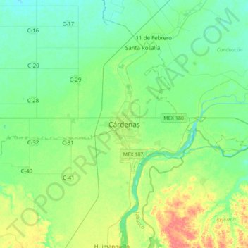
Name: Cárdenas topographic map, elevation, terrain.
Location: Cárdenas, Tabasco, 86500, México (17.83088 -93.53533 18.15088 -93.21533)
Average elevation: 66 ft
Minimum elevation: 20 ft
Maximum elevation: 174 ft
Other topographic maps
Click on a map to view its topography, its elevation and its terrain.
Parque Juárez
México > Tabasco > Cárdenas > Cárdenas
Parque Juárez, Heroica Cardenas, Cárdenas, Tabasco, 86500, México
Average elevation: 75 ft