
Shimla topographic map
Interactive map
Click on the map to display elevation.
About this map
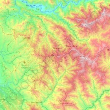
Name: Shimla topographic map, elevation, terrain.
Average elevation: 5,108 ft
Minimum elevation: 2,028 ft
Maximum elevation: 9,272 ft
Shimla is on the south-western ranges of the Himalayas at 31°37′N 77°06′E / 31.61°N 77.10°E / 31.61; 77.10. It has an average altitude of 2,206 metres (7,238 ft) above mean sea level and extends along a ridge with seven spurs. The city stretches nearly 9.2 kilometres (5.7 mi) from east to west.
Other topographic maps
Click on a map to view its topography, its elevation and its terrain.
Chakar
India > Himachal Pradesh > Shimla (urban)
Chakar, Shimla (urban), Shimla District, Himachal Pradesh, 171005, India
Average elevation: 5,892 ft
Jutogh
India > Himachal Pradesh > Shimla (urban)
Jutogh, Shimla (urban), Shimla District, Himachal Pradesh, 171005, India
Average elevation: 5,856 ft
Bharari
India > Himachal Pradesh > Shimla (urban)
Bharari, Shimla (urban), Shimla District, Himachal Pradesh, 171003, India
Average elevation: 6,106 ft