
Peterborough topographic map
Interactive map
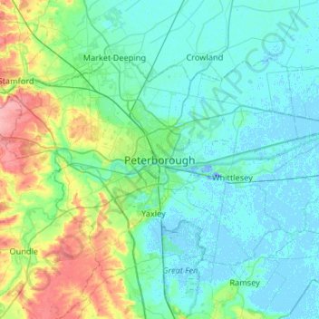
Click on the map to display elevation.
About this map
Name: Peterborough topographic map, elevation, terrain.
Average elevation: 56 ft
Minimum elevation: -62 ft
Maximum elevation: 302 ft
The local topography is flat, and in some places, the land lies below sea level, for example in parts of the Fens to the east and to the south of Peterborough. Human settlement in the area began before the Bronze Age, as can be seen at the Flag Fen archaeological site to the east of the current city centre, also with evidence of Roman occupation. The Anglo-Saxon period saw the establishment of a monastery, Medeshamstede, which later became Peterborough Cathedral.
Other topographic maps
Click on a map to view its topography, its elevation and its terrain.
Castor
United Kingdom > England > City of Peterborough
Castor, City of Peterborough, Cambridgeshire and Peterborough, England, United Kingdom
Average elevation: 82 ft
Thorney
United Kingdom > England > City of Peterborough
Thorney, City of Peterborough, Cambridgeshire and Peterborough, England, United Kingdom
Average elevation: 7 ft
Northborough
United Kingdom > England > City of Peterborough
Northborough, City of Peterborough, Cambridgeshire and Peterborough, England, United Kingdom
Average elevation: 26 ft