
County Donegal topographic map
Interactive map
Click on the map to display elevation.
About this map
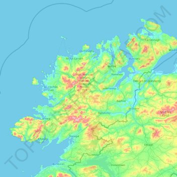
Name: County Donegal topographic map, elevation, terrain.
Location: County Donegal, Ulster, Ireland (54.45905 -8.83471 55.43530 -6.92273)
Average elevation: 243 ft
Minimum elevation: -13 ft
Maximum elevation: 2,287 ft
The majority of Donegal has a temperate oceanic climate (Köppen climate classification: Cfb), with upland areas in the Derryveagh and Blue Stack ranges classified as oceanic subpolar (Köppen climate classification: Cfc). The county's climate is heavily influenced by the North Atlantic Current. Due to the topography of western Donegal, it receives orographic rainfall, where the air is forced to rise on contact with its mountainous coastline and subsequently cools and condenses, forming clouds. The mountains of Donegal are among the cloudiest places in Ireland, and northern Donegal is the windiest. Irish monthly record wind speeds for March, June, July, September, November and December have all been set at Malin Head. The highest wind speed ever recorded in Donegal was 181 km/h (112 mph) on 16 September 1961, during Hurricane Debbie.
Other topographic maps
Click on a map to view its topography, its elevation and its terrain.
Athlone
Athlone, County Westmeath, Leinster, Ireland
Average elevation: 141 ft
Lismore
Lismore, The Municipal District of Dungarvan — Lismore, County Waterford, Munster, P51 VW44, Ireland
Average elevation: 125 ft
Kilmichael
Kilmichael, Carrigboy ED, Municipal District of Macroom, County Cork, Munster, P12 W864, Ireland
Average elevation: 436 ft
Macroom
Macroom, Municipal District of Macroom, County Cork, Munster, Ireland
Average elevation: 361 ft
Great Skellig
Great Skellig, Kenmare Municipal District, County Kerry, Munster, Ireland
Average elevation: 3 ft
Boston
Boston, Boston ED, West Clare Municipal District, County Clare, Munster, H91 R9FX, Ireland
Average elevation: 82 ft
Cashel
Cashel, The Municipal District of Cahir — Cashel, County Tipperary, Munster, Ireland
Average elevation: 377 ft
Acres
Acres, Aghavas ED, Ballinamore Municipal District, County Leitrim, Connacht, Ireland
Average elevation: 243 ft
Curraghboy
Curraghboy, Rockhill Electoral Division, Athlone Municipal District, County Roscommon, Connacht, N37 EK20, Ireland
Average elevation: 226 ft
Furbo
Furbo, County Galway, Connacht, H91 KX27, Ireland
Average elevation: 52 ft
Headford
Headford, Headford ED, Tuam Municipal District, County Galway, Connacht, Ireland
Average elevation: 66 ft
Curtaun
Curtaun, Beagh ED, Loughrea Municipal District, County Galway, Connacht, Ireland
Average elevation: 89 ft
Leamlara
Leamlara, Lisgoold, The Municipal District of East Cork, County Cork, Munster, T56 NH57, Ireland
Average elevation: 476 ft
Naas
Naas, The Municipal District of Naas, County Kildare, Leinster, Ireland
Average elevation: 318 ft
Killeens
Killeens, Coolhill, The Municipal District of Callan — Thomastown, County Kilkenny, Leinster, Ireland
Average elevation: 207 ft
Lecks
Lecks, Shercock ED, Bailieborough-Cootehill Municipal District, County Cavan, Ireland
Average elevation: 420 ft
Ballybrack
Ireland > County Dublin > Killiney
Ballybrack, Killiney North DED 1986, Killiney, Dún Laoghaire-Rathdown, County Dublin, Leinster, Ireland
Average elevation: 105 ft
Manorhamilton Municipal District
Manorhamilton Municipal District, County Leitrim, Connacht, Ireland
Average elevation: 512 ft
Matehy
Matehy, Municipal District of Macroom, County Cork, Munster, Ireland
Average elevation: 351 ft
Keshcarrigan
Keshcarrigan, Ballinamore Municipal District, County Leitrim, Connacht, Ireland
Average elevation: 256 ft
Kiltegan
Kiltegan, The Municipal District of Baltinglass, County Wicklow, Leinster, Ireland
Average elevation: 492 ft
Newmarket
Newmarket, The Municipal District of Kanturk-Mallow, County Cork, Munster, Ireland
Average elevation: 554 ft
Killarney
Killarney, Killarney Municipal District, County Kerry, Munster, Ireland
Average elevation: 187 ft
Newbridge
Newbridge, The Municipal District of Kildare — Newbridge, County Kildare, Leinster, Ireland
Average elevation: 312 ft
Mullyash
Mullyash, Mullyash ED, Carrickmacross-Castleblaney Municipal District, County Monaghan, Ulster, Ireland
Average elevation: 725 ft
Watergrasshill
Watergrasshill, Municipal District of Cobh, County Cork, Munster, Ireland
Average elevation: 538 ft
Horseleap
Horseleap, The Municipal District of Tullamore, County Offaly, Leinster, Ireland
Average elevation: 230 ft
Claremorris-Swinford Municipal District
Claremorris-Swinford Municipal District, County Mayo, Connacht, Ireland
Average elevation: 226 ft
White River
White River, Dunleer ED, The Municipal District of Ardee, County Louth, Leinster, A92 RP77, Ireland
Average elevation: 246 ft
Cork City
Ireland > County Cork > Cork
Cork City, Cork, County Cork, Munster, Ireland
Average elevation: 217 ft
Bellananagh
Bellananagh, Bellananagh ED, Ballyjamesduff Municipal District, County Cavan, H12 K727, Ireland
Average elevation: 308 ft
Gurteen
Gurteen, Cappalusk ED, Athenry-Oranmore Municipal District, County Galway, Connacht, Ireland
Average elevation: 292 ft
Carrickmines Little
Ireland > County Dublin > Ballyogan
Carrickmines Little, Glencullen Electoral Division, Ballyogan, Dún Laoghaire-Rathdown, County Dublin, Leinster, Ireland
Average elevation: 272 ft
Cahir
Cahir, The Municipal District of Cahir — Cashel, County Tipperary, Munster, Ireland
Average elevation: 190 ft
Spink
Spink, The Municipal District of Portlaoise, County Laois, Leinster, Ireland
Average elevation: 719 ft
Municipal District of Carrigaline
Municipal District of Carrigaline, County Cork, Munster, Ireland
Average elevation: 171 ft
Curracloe
Curracloe, The Borough District of Wexford, County Wexford, Leinster, Y21 DP62, Ireland
Average elevation: 69 ft
Harlockstown
Harlockstown, Ratoath ED, The Municipal District of Ratoath, County Meath, Leinster, Ireland
Average elevation: 240 ft
Glassilaun Beach
Glassilaun Beach, Cushkillary ED, Conamara Municipal District, County Galway, Connacht, Ireland
Average elevation: 36 ft
Clare Island
Clare Island, Westport-Belmullet Municipal District, County Mayo, Connacht, Ireland
Average elevation: 95 ft
Halfway
Halfway, Dunderrow, Municipal District of Carrigaline, County Cork, Munster, T12 KT99, Ireland
Average elevation: 315 ft
Eyrephort
Eyrephort, Clifden ED, Conamara Municipal District, County Galway, Connacht, Ireland
Average elevation: 20 ft
Mortgage
Ireland > County Limerick > The Municipal District of Adare — Rathkeale
Mortgage, Rathmore, The Municipal District of Adare — Rathkeale, County Limerick, Munster, Ireland
Average elevation: 197 ft
Killumney
Killumney, Ballygroman ED, Municipal District of Macroom, County Cork, Munster, Ireland
Average elevation: 259 ft
Saleen
Saleen, Hollymount Electoral Division, Claremorris-Swinford Municipal District, County Mayo, Connacht, Ireland
Average elevation: 112 ft