
Limeira topographic map
Interactive map
Click on the map to display elevation.
About this map
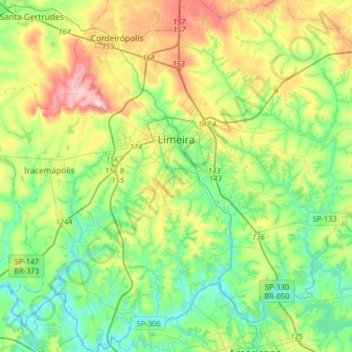
Name: Limeira topographic map, elevation, terrain.
Average elevation: 1,965 ft
Minimum elevation: 1,614 ft
Maximum elevation: 2,707 ft
Limeira is a city in the eastern part of the Brazilian state of São Paulo. The population is 300,911 (2017 est.) in an area of 581 km². The elevation is 588 m. It is 154 km from São Paulo, the state capital, and 1011 km from Brasilia, Brazil's capital. The city can be easily reached from São Paulo by two highways: Rodovia Anhanguera and Rodovia dos Bandeirantes.