
Miquelon-Langlade topographic map
Interactive map
Click on the map to display elevation.
About this map
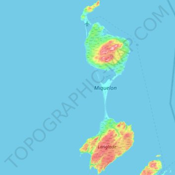
Name: Miquelon-Langlade topographic map, elevation, terrain.
Location: Miquelon-Langlade, Saint-Pierre-et-Miquelon, 97500, France (46.78254 -56.40588 47.14426 -56.23748)
Average elevation: 33 ft
Minimum elevation: -3 ft
Maximum elevation: 748 ft
Other topographic maps
Click on a map to view its topography, its elevation and its terrain.
Saint-Pierre-et-Miquelon
France > Saint-Pierre-et-Miquelon
Saint-Pierre-et-Miquelon, France
Average elevation: 36 ft
Saint-Pierre-et-Miquelon
France > Saint-Pierre-et-Miquelon
Saint-Pierre-et-Miquelon, France
Average elevation: 16 ft