
Panguitch topographic map
Interactive map
Click on the map to display elevation.
About this map
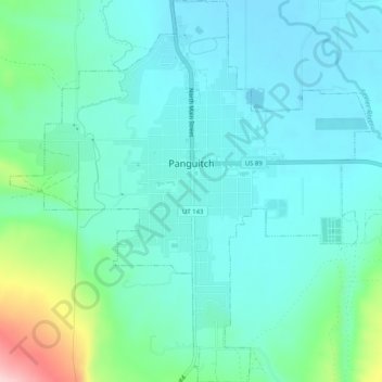
Name: Panguitch topographic map, elevation, terrain.
Location: Panguitch, Garfield County, Utah, United States (37.79979 -112.45990 37.83991 -112.41164)
Average elevation: 6,703 ft
Minimum elevation: 6,552 ft
Maximum elevation: 7,326 ft
Panguitch has a cool semi-arid climate (Köppen BSk) with summers featuring hot afternoons and cold mornings, and cold, dry winters. The high altitude and relatively high latitude means that mornings are cold throughout the year and freezing for most of it: between 1971 and 2000 an average of 227.7 mornings fell below freezing and 16.5 mornings fell to or below 0 °F (−17.8 °C). Maxima, however, can be expected to top freezing on all but fourteen afternoons during an average year, and the winters are so dry that snowfall is light, averaging only 19.2 inches or 0.49 metres with median cover never much above 1 inch or 0.025 metres. The most snowfall in a month has been 32.0 inches (0.81 m) in the famously cold January 1949, and the most in a season 48.5 inches (1.23 m) from July 1951 to June 1952. Mild, dry winters like 1976/1977 and 1980/1981 can in contrast see negligible snowfall for an entire season.
Other topographic maps
Click on a map to view its topography, its elevation and its terrain.
Hite Point
United States > Utah > Garfield County
Hite Point, Garfield County, Utah, United States
Average elevation: 4,423 ft
Cannonville
United States > Utah > Garfield County
Cannonville, Garfield County, Utah, 84718, United States
Average elevation: 6,214 ft
Panguitch Lake
United States > Utah > Garfield County
Panguitch Lake, Garfield County, Utah, United States
Average elevation: 8,294 ft
Bryce Canyon National Park
United States > Utah > Garfield County
Bryce Canyon National Park, Garfield County, Utah, United States
Average elevation: 7,411 ft
Upper Calf Creek Fall
United States > Utah > Garfield County
Upper Calf Creek Fall, Garfield County, Utah, 84716, United States
Average elevation: 6,247 ft
Piracy Point
United States > Utah > Garfield County
Piracy Point, Bryce Canyon Scenic Drive, Garfield County, Utah, United States
Average elevation: 8,369 ft
Henderson Creek
United States > Utah > Garfield County
Henderson Creek, Garfield County, Utah, 84776, United States
Average elevation: 6,617 ft
Antimony
United States > Utah > Garfield County
Antimony, Garfield County, Utah, 84712, United States
Average elevation: 6,762 ft
Bryce Canyon
United States > Utah > Garfield County > Tropic
Bryce Canyon, Tropic, Garfield County, Utah, United States
Average elevation: 7,372 ft
Escalante
United States > Utah > Garfield County
Escalante, Garfield County, Utah, 84726, United States
Average elevation: 5,843 ft
Hatch
United States > Utah > Garfield County
Hatch, Garfield County, Utah, 84735, United States
Average elevation: 7,005 ft
Bryce Canyon City
United States > Utah > Garfield County > Bryce Canyon City
Bryce Canyon City, Garfield County, Utah, 84764, United States
Average elevation: 7,667 ft
Panguitch
United States > Utah > Garfield County > Panguitch
Panguitch, Garfield County, Utah, 87459, United States
Average elevation: 6,827 ft
Andy Miller Flats
United States > Utah > Garfield County
Andy Miller Flats, Garfield County, Utah, United States
Average elevation: 5,262 ft
Capitol Reef National Park
United States > Utah > Garfield County
Capitol Reef National Park, Garfield County, Utah, United States
Average elevation: 6,440 ft