
Sint-Michiels topographic map
Interactive map
Click on the map to display elevation.
About this map
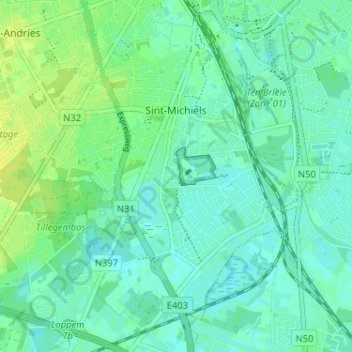
Name: Sint-Michiels topographic map, elevation, terrain.
Average elevation: 23 ft
Minimum elevation: 3 ft
Maximum elevation: 52 ft
Other topographic maps
Click on a map to view its topography, its elevation and its terrain.
Zeebrugge
Belgium > West Flanders > Brugge > Bruges
Zeebrugge, Lissewege, Bruges, Brugge, West Flanders, Belgium
Average elevation: 7 ft
Bruges
Belgium > West Flanders > Brugge > Bruges
Bruges, Brugge, West Flanders, Flanders, 8000, Belgium
Average elevation: 23 ft