
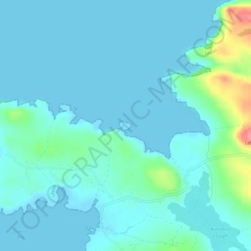
Inishowen topographic map
Interactive map
Click on the map to display elevation.
About this map
Name: Inishowen topographic map, elevation, terrain.
Average elevation: 43 ft
Minimum elevation: -7 ft
Maximum elevation: 295 ft
Other topographic maps
Click on a map to view its topography, its elevation and its terrain.
Kiltole
Kiltole, Figart ED, Lifford-Stranorlar Municipal District, County Donegal, Ireland
Average elevation: 161 ft
Teelin
Teelin, Donegal Municipal District, County Donegal, Ireland
Average elevation: 289 ft
Rathmullan
Rathmullan, County Donegal, F92 DH90, Ireland
Average elevation: 62 ft
Carn Hill
Ireland > County Donegal > Letterkenny
Carn Hill, Letterkenny, County Donegal, F92 W8CY, Ireland
Average elevation: 472 ft
Lisnenan
Ireland > County Donegal > Letterkenny
Lisnenan, Letterkenny Rural ED, Letterkenny, County Donegal, F92 W8CY, Ireland
Average elevation: 331 ft
Glencar Scotch
Ireland > County Donegal > Letterkenny
Glencar Scotch, Letterkenny Rural ED, Letterkenny, County Donegal, Ireland
Average elevation: 440 ft
Trillick
Trillick, Buncrana Rural ED, Inishowen Municipal District, County Donegal, Ulster, Ireland
Average elevation: 348 ft
Glen Lough
Ireland > County Donegal > Letterkenny
Glen Lough, Millford ED, Letterkenny, County Donegal, Ulster, Ireland
Average elevation: 292 ft
Stragraddy
Ireland > County Donegal > Letterkenny
Stragraddy, Termon ED, Letterkenny, County Donegal, Ulster, Ireland
Average elevation: 387 ft
Letterkenny
Ireland > County Donegal > Letterkenny
Letterkenny, Letterkenny Municipal District, County Donegal, F92 PD92, Ireland
Average elevation: 305 ft
Donegal Bay
Donegal Bay, County Donegal, Ulster, Ireland
Average elevation: 125 ft
Church Hill
Ireland > County Donegal > Letterkenny
Church Hill, Church Hill ED, Letterkenny, County Donegal, Ireland
Average elevation: 384 ft
Gortahork
Gortahork, Gleneely ED, Lifford-Stranorlar Municipal District, County Donegal, Ireland
Average elevation: 568 ft
Bomany
Ireland > County Donegal > Letterkenny
Bomany, Ballymacool ED, Letterkenny, County Donegal, Ulster, Ireland
Average elevation: 203 ft
Murvagh Upper Glebe
Murvagh Upper Glebe, Ballintra ED, Donegal Municipal District, County Donegal, Ireland
Average elevation: 23 ft
Inver Glebe
Inver Glebe, Inver ED, Donegal Municipal District, County Donegal, Ireland
Average elevation: 85 ft
Castlefinn
Castlefinn, Castlefinn ED, Lifford-Stranorlar Municipal District, County Donegal, Ulster, Ireland
Average elevation: 89 ft
Inishowen Municipal District
Inishowen Municipal District, County Donegal, Ireland
Average elevation: 194 ft
Moness
Moness, Burt ED, Inishowen Municipal District, County Donegal, Ireland
Average elevation: 174 ft
Moness
Moness, St Johnstown Electoral Division, Lifford-Stranorlar Municipal District, County Donegal, Ireland
Average elevation: 180 ft
Toulett
Toulett, Burt ED, Inishowen Municipal District, County Donegal, Ireland
Average elevation: 292 ft
Sallaghagrane
Ireland > County Donegal > Letterkenny
Sallaghagrane, Letterkenny Rural ED, Letterkenny, County Donegal, Ulster, Ireland
Average elevation: 187 ft
Dungloe River
Dungloe River, Dunglow ED, Glenties Municipal District, County Donegal, Ulster, F94 W974, Ireland
Average elevation: 79 ft
Murvagh Beach
Murvagh Beach, Ballintra ED, Donegal Municipal District, County Donegal, Ireland
Average elevation: 7 ft
Cashel
Cashel, Donegal Municipal District, County Donegal, Ireland
Average elevation: 354 ft
Lifford-Stranorlar Municipal District
Lifford-Stranorlar Municipal District, County Donegal, Ulster, Ireland
Average elevation: 466 ft
Cark
Cark, Lettermore ED, Lifford-Stranorlar Municipal District, County Donegal, Ireland
Average elevation: 840 ft
Tory Island
Tory Island, Meenaclady, Glenties Municipal District, County Donegal, Ireland
Average elevation: 10 ft
Horn Head
Horn Head, Dunfanaghy Electoral Division, Glenties Municipal District, County Donegal, F92 H0CY, Ireland
Average elevation: 102 ft
Creeslough ED
Creeslough ED, Glenties Municipal District, County Donegal, Ulster, F92 W803, Ireland
Average elevation: 141 ft
Kilmacrennan
Ireland > County Donegal > Kilmacrennan
Kilmacrennan, Letterkenny Municipal District, County Donegal, Ireland
Average elevation: 207 ft
Drumaneary
Drumaneary, Tantallon ED, Donegal Municipal District, County Donegal, Ireland
Average elevation: 75 ft
Gortnamuck
Gortnamuck, Cloghard ED, Lifford-Stranorlar Municipal District, County Donegal, Ireland
Average elevation: 285 ft
Melmore Head
Ireland > County Donegal > Letterkenny
Melmore Head, Atlantic Way, Rosguill ED, Letterkenny, County Donegal, Ireland
Average elevation: 30 ft
Drumnacross
Drumnacross, Ardara ED, Glenties Municipal District, County Donegal, Ireland
Average elevation: 289 ft
Donegal Municipal District
Donegal Municipal District, County Donegal, Ulster, Ireland
Average elevation: 394 ft
Dunduffsfort
Dunduffsfort, Newtown Cunningham ED, Inishowen Municipal District, County Donegal, Ireland
Average elevation: 249 ft
Kildoney Glebe
Kildoney Glebe, Ballyshannon Rural ED, Donegal Municipal District, County Donegal, Ireland
Average elevation: 43 ft
Ballyargus
Ballyargus, Redcastle ED, Inishowen Municipal District, County Donegal, Ireland
Average elevation: 554 ft
Dunglow
Dunglow, Dunglow ED, Glenties Municipal District, County Donegal, Ulster, Ireland
Average elevation: 85 ft
Duncap Isle
Duncap Isle, Dunfanaghy Electoral Division, Glenties Municipal District, County Donegal, F92 H0CY, Ireland
Average elevation: 125 ft
Lough Derryduff
Lough Derryduff, Maas ED, Glenties Municipal District, County Donegal, Ireland
Average elevation: 135 ft
Inishinny
Inishinny, Rutland ED, Glenties Municipal District, County Donegal, Ireland
Average elevation: 7 ft
Largynagreana
Largynagreana, Killybegs ED, Donegal Municipal District, County Donegal, Ireland
Average elevation: 305 ft
Speenoge
Speenoge, Burt ED, Inishowen Municipal District, County Donegal, Ireland
Average elevation: 259 ft
Cullion
Cullion, Lettermacaward ED, Glenties Municipal District, County Donegal, Ireland
Average elevation: 95 ft
Lough Lilly
Lough Lilly, Altnapaste ED, Lifford-Stranorlar Municipal District, County Donegal, Ireland
Average elevation: 738 ft