
Zillebeke topographic map
Interactive map
Click on the map to display elevation.
About this map
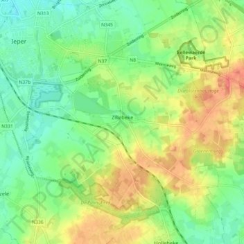
Name: Zillebeke topographic map, elevation, terrain.
Location: Zillebeke, Ypres, Ieper, West Flanders, Flanders, 8902, Belgium (50.81278 2.88746 50.85426 2.97650)
Average elevation: 118 ft
Minimum elevation: 36 ft
Maximum elevation: 230 ft
Other topographic maps
Click on a map to view its topography, its elevation and its terrain.
Dikkebus
Belgium > West Flanders > Ieper > Ypres
Dikkebus, Ypres, Ieper, West Flanders, Belgium
Average elevation: 102 ft
Ypres
Belgium > West Flanders > Ieper > Ypres
Ypres, Ieper, West Flanders, Flanders, 8900, Belgium
Average elevation: 79 ft