
Kent topographic map
Interactive map
Click on the map to display elevation.
About this map
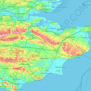
Name: Kent topographic map, elevation, terrain.
Location: Kent, South East, England, United Kingdom (50.91048 0.03352 51.48227 1.45177)
Average elevation: 121 ft
Minimum elevation: -10 ft
Maximum elevation: 863 ft
Kent was also the location of the largest number of art schools in the country during the nineteenth century, estimated by the art historian David Haste, to approach two hundred. This is believed to be the result of Kent being a front line county during the Napoleonic Wars. At this time, before the invention of photography, draughtsmen were used to draw maps and topographical representations of the fields of battle, and after the wars ended many of these settled permanently in the county in which they had been based. Once the idea of art schools had been established, even in small towns in Kent, the tradition continued, although most of the schools were very small one man operations, each teaching a small number of daughters of the upper classes how to draw and make watercolour paintings. Nonetheless, some of these small art schools developed into much larger organisations, including Canterbury College of Art, founded by Thomas Sidney Cooper in 1868, which is today the University for the Creative Arts.
Other topographic maps
Click on a map to view its topography, its elevation and its terrain.
City of London
United Kingdom > England > City of London > City of London
City of London, England, EC2V 5AE, United Kingdom
Average elevation: 138 ft
London
London, Greater London, England, United Kingdom
Average elevation: 217 ft
Dalbury
United Kingdom > England > Derbyshire > South Derbyshire
Dalbury, Dalbury Lees CP, South Derbyshire, Derbyshire, England, DE6 5BR, United Kingdom
Average elevation: 249 ft
Fenny Bentley CP
United Kingdom > England > Derbyshire > Derbyshire Dales
Fenny Bentley CP, Derbyshire Dales, Derbyshire, England, United Kingdom
Average elevation: 633 ft
Kingsley Holt
United Kingdom > England > Staffordshire > Staffordshire Moorlands
Kingsley Holt, Staffordshire Moorlands, Staffordshire, England, ST10 2BG, United Kingdom
Average elevation: 604 ft
Northampton
United Kingdom > England > West Northamptonshire > Northampton
Northampton, West Northamptonshire, England, United Kingdom
Average elevation: 292 ft
Water
United Kingdom > England > Devon > Teignbridge
Water, Teignbridge, Devon, England, TQ13 9UE, United Kingdom
Average elevation: 856 ft
Stonehenge
United Kingdom > England > Larkhill
Stonehenge, The Avenue, Amesbury, Larkhill, Wiltshire, South West England, England, SP3 4DX, United Kingdom
Average elevation: 325 ft
Shrewsbury
United Kingdom > England > Shrewsbury
Shrewsbury, Shropshire, West Midlands, England, SY1 1SF, United Kingdom
Average elevation: 233 ft
Alvescot
United Kingdom > England > Oxfordshire > West Oxfordshire
Alvescot, West Oxfordshire, Oxfordshire, England, United Kingdom
Average elevation: 285 ft
Hadfield
United Kingdom > England > Derbyshire > High Peak
Hadfield, High Peak, Derbyshire, England, United Kingdom
Average elevation: 571 ft
Sunderland
Sunderland, North East, England, United Kingdom
Average elevation: 151 ft
Derbyshire Dales
United Kingdom > England > Derbyshire
Derbyshire Dales, Derbyshire, England, United Kingdom
Average elevation: 650 ft
Alfreton Park
United Kingdom > England > Derbyshire > Amber Valley > Alfreton CP > Oakerthorpe
Alfreton Park, Alfreton CP, Oakerthorpe, Amber Valley, Derbyshire, England, DE55 7AL, United Kingdom
Average elevation: 381 ft
Welford
United Kingdom > England > West Berkshire
Welford, West Berkshire, England, United Kingdom
Average elevation: 407 ft
Great Shefford
United Kingdom > England > West Berkshire
Great Shefford, West Berkshire, England, United Kingdom
Average elevation: 486 ft
Hazelwood CP
United Kingdom > England > Derbyshire > Amber Valley
Hazelwood CP, Amber Valley, Derbyshire, England, United Kingdom
Average elevation: 361 ft
Heamoor
United Kingdom > England > Cornwall > Penzance
Heamoor, Penzance, Cornwall, England, TR18 3GD, United Kingdom
Average elevation: 230 ft
River Glen
United Kingdom > England > Northumberland > Kirknewton
River Glen, Kirknewton, Northumberland, North of Tyne, England, United Kingdom
Average elevation: 318 ft
Muckleford
United Kingdom > England > Dorset > Grimstone
Muckleford, Bradford Peverell, Grimstone, Dorset, England, DT2 9SW, United Kingdom
Average elevation: 374 ft
Amport
United Kingdom > England > Hampshire > Test Valley
Amport, Test Valley, Hampshire, England, United Kingdom
Average elevation: 312 ft
Brook
United Kingdom > England > Hampshire > New Forest > Bramshaw
Brook, Bramshaw, New Forest, Hampshire, England, SO43 7HE, United Kingdom
Average elevation: 213 ft
Stapleford Abbotts
United Kingdom > England > Epping Forest
Stapleford Abbotts, Epping Forest, Essex, England, United Kingdom
Average elevation: 194 ft
Cusworth
United Kingdom > England > Doncaster
Cusworth, Doncaster, South Yorkshire, England, DN5 8UZ, United Kingdom
Average elevation: 82 ft
Middleton Cheney
United Kingdom > England > West Northamptonshire
Middleton Cheney, West Northamptonshire, England, United Kingdom
Average elevation: 420 ft
Rotherham
Rotherham, South Yorkshire Mayoral Combined Authority, England, United Kingdom
Average elevation: 331 ft
Lew
United Kingdom > England > Oxfordshire > West Oxfordshire
Lew, West Oxfordshire, Oxfordshire, England, United Kingdom
Average elevation: 259 ft
Yorkshire Dales National Park
Yorkshire Dales National Park, England, United Kingdom
Average elevation: 978 ft
Pinewoods
United Kingdom > England > North Yorkshire > Harrogate
Pinewoods, Duchy, Harrogate, North Yorkshire, England, United Kingdom
Average elevation: 456 ft
Crediton
United Kingdom > England > Devon > Mid Devon
Crediton, Mid Devon, Devon, England, United Kingdom
Average elevation: 233 ft
Selattyn
United Kingdom > England > Shropshire
Selattyn, Shropshire, England, SY10 7EZ, United Kingdom
Average elevation: 794 ft
Down Ampney
United Kingdom > England > Gloucestershire > Cotswold District
Down Ampney, Cotswold District, Gloucestershire, England, GL7 5QR, United Kingdom
Average elevation: 279 ft
The Swag
United Kingdom > England > Walsall > Shelfield > Stubbers Green
The Swag, Barn's Lane, Stubbers Green, Shelfield, Walsall, West Midlands Combined Authority, England, United Kingdom
Average elevation: 469 ft
Buckover
United Kingdom > England > South Gloucestershire > Thornbury > Milbury Heath
Buckover, Milbury Heath, Thornbury, South Gloucestershire, West of England, England, GL12 8DX, United Kingdom
Average elevation: 213 ft
Cambourne
United Kingdom > England > Cambridgeshire > South Cambridgeshire
Cambourne, South Cambridgeshire, Cambridgeshire, Cambridgeshire and Peterborough, England, United Kingdom
Average elevation: 207 ft
Derehams Park
United Kingdom > England > Buckinghamshire > Loudwater
Derehams Park, Rayners Avenue Mobile Home Park, Chepping Wycombe, Beaconsfield and Chepping Wye Community Board, Loudwater, Buckinghamshire, England, United Kingdom
Average elevation: 312 ft
Red Lodge
United Kingdom > England > Suffolk > West Suffolk
Red Lodge, West Suffolk, Suffolk, England, United Kingdom
Average elevation: 72 ft
River Esk
United Kingdom > England > North Yorkshire
River Esk, North Yorkshire, England, United Kingdom
Average elevation: 620 ft
Burn
United Kingdom > England > Norfolk > King's Lynn and West Norfolk > Burnham Overy
Burn, Burnham Overy, King's Lynn and West Norfolk, Norfolk, England, PE31 8DX, United Kingdom
Average elevation: 52 ft
Royal Leamington Spa
United Kingdom > England > Royal Leamington Spa
Royal Leamington Spa, Warwickshire, West Midlands, England, CV32 4DB, United Kingdom
Average elevation: 223 ft
Evershot
United Kingdom > England > Dorset
Evershot, Dorset, England, United Kingdom
Average elevation: 512 ft
Wool
United Kingdom > England > Dorset > Bovington
Wool, Bovington, Dorset, England, United Kingdom
Average elevation: 121 ft
Milburn
United Kingdom > England > Westmorland and Furness
Milburn, Westmorland and Furness, England, United Kingdom
Average elevation: 1,050 ft
Nappa
United Kingdom > England > North Yorkshire > Halton West
Nappa, Hellifield, Halton West, North Yorkshire, England, BD23 4LT, United Kingdom
Average elevation: 505 ft
Willington Quay
United Kingdom > England > North Tyneside > Wallsend
Willington Quay, Howdon, Wallsend, North Tyneside, North of Tyne, England, NE28 6EA, United Kingdom
Average elevation: 75 ft
Bramhall
Bramhall, Stockport, Greater Manchester, England, SK7 2JJ, United Kingdom
Average elevation: 269 ft
West Tytherley
United Kingdom > England > Hampshire > Test Valley
West Tytherley, Test Valley, Hampshire, England, United Kingdom
Average elevation: 240 ft
White City
United Kingdom > England > Gloucestershire > Gloucester
White City, Gloucester, Gloucestershire, England, GL4 6UL, United Kingdom
Average elevation: 125 ft
Goblin Ledge
United Kingdom > England > South Gloucestershire > Severn Beach > New Passage
Goblin Ledge, Prince of Wales Bridge, New Passage, Pilning and Severn Beach, Severn Beach, South Gloucestershire, West of England, England, BS35 4NQ, United Kingdom
Average elevation: 7 ft