
Mont Blanc - Monte Bianco topographic map
Interactive map
Click on the map to display elevation.
About this map
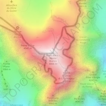
Name: Mont Blanc - Monte Bianco topographic map, elevation, terrain.
Average elevation: 13,425 ft
Minimum elevation: 10,981 ft
Maximum elevation: 15,761 ft
The climate is cold and temperate (Köppen climate classification Cfb), and is greatly influenced by altitude. Being the highest part of the Alps, Mont Blanc and surrounding mountains can create their own weather patterns. Temperatures drop as the mountains gain in height, and the summit of Mont Blanc is a permanent ice cap, with temperatures around −20 °C (−4 °F). The summit is also prone to strong winds and sudden weather changes. Because of its great overall height, a considerable proportion is permanently glaciated or snow-covered and is exposed to extremely cold conditions.
Other topographic maps
Click on a map to view its topography, its elevation and its terrain.
Larzey
Italy > Aosta Valley > Courmayeur
Larzey, Courmayeur, Aosta Valley, 11013, Italy
Average elevation: 5,236 ft
Val Veny
Italy > Aosta Valley > Courmayeur
Val Veny, Courmayeur, Aosta Valley, Italy
Average elevation: 7,057 ft
Ghiacciaio del Miage
Italy > Aosta Valley > Courmayeur
Ghiacciaio del Miage, Sentiero 15 Rifugio Gonella, Courmayeur, Aosta Valley, Italy
Average elevation: 9,551 ft