
Brussels-Capital topographic map
Interactive map
Click on the map to display elevation.
About this map
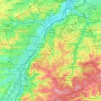
Name: Brussels-Capital topographic map, elevation, terrain.
Location: Brussels-Capital, Belgium (50.76368 4.24377 50.91390 4.48227)
Average elevation: 203 ft
Minimum elevation: 33 ft
Maximum elevation: 459 ft
Brussels lies in the north-central part of Belgium, about 110 km (68 mi) from the Belgian coast and about 180 km (110 mi) from Belgium's southern tip. It is located in the heartland of the Brabantian Plateau, about 45 km (28 mi) south of Antwerp (Flanders), and 50 km (31 mi) north of Charleroi (Wallonia). Its average elevation is 57 m (187 ft) above sea level, varying from a low point in the valley of the almost completely covered Senne, which cuts the Brussels-Capital Region from east to west, up to high points in the Sonian Forest, on its southeastern side. In addition to the Senne, tributary streams such as the Maalbeek and the Woluwe, to the east of the region, account for significant elevation differences. Brussels' central boulevards are 15 m (49 ft) above sea level. Contrary to popular belief, the highest point (at 127.5 m (418 ft)) is not near the Place de l'Altitude Cent/Hoogte Honderdplein in Forest, but at the Drève des Deux Montages/Tweebergendreef in the Sonian Forest.
Other topographic maps
Click on a map to view its topography, its elevation and its terrain.
Tongre-Notre-Dame
Tongre-Notre-Dame, Chièvres, Ath, Hainaut, Wallonia, 7951, Belgium
Average elevation: 184 ft
Kortrijk
Belgium > West Flanders > Kortrijk
Kortrijk, West Flanders, Flanders, Belgium
Average elevation: 89 ft
Neufchâteau
Belgium > Luxembourg > Neufchâteau
Neufchâteau, Luxembourg, Wallonia, 6840, Belgium
Average elevation: 1,434 ft
Bellecourt
Belgium > Hainaut > Soignies > Manage
Bellecourt, Manage, Soignies, Hainaut, Wallonia, 7170, Belgium
Average elevation: 502 ft
Geraardsbergen
Belgium > East Flanders > Aalst
Geraardsbergen, Aalst, East Flanders, Flanders, Belgium
Average elevation: 131 ft
Bredene
Belgium > West Flanders > Ostend > Bredene
Bredene, Ostend, West Flanders, Flanders, 8450, Belgium
Average elevation: 7 ft
Braine-le-Comte
Braine-le-Comte, Soignies, Hainaut, Wallonia, 7090, Belgium
Average elevation: 292 ft
Zonnebeke
Belgium > West Flanders > Ieper
Zonnebeke, Ieper, West Flanders, 8980, Belgium
Average elevation: 98 ft
Viroinval
Belgium > Namur > Philippeville
Viroinval, Philippeville, Namur, Wallonia, 5670, Belgium
Average elevation: 846 ft
Horebeke
Belgium > East Flanders > Oudenaarde
Horebeke, Oudenaarde, East Flanders, Flanders, 9667, Belgium
Average elevation: 220 ft
Haut-Ittre
Belgium > Walloon Brabant > Nivelles
Haut-Ittre, Ittre, Nivelles, Walloon Brabant, Wallonia, 1461, Belgium
Average elevation: 417 ft
Uitbergen
Belgium > East Flanders > Dendermonde > Berlare
Uitbergen, Berlare, Dendermonde, East Flanders, Belgium
Average elevation: 10 ft
Sint-Pieters-Leeuw
Belgium > Flemish Brabant > Halle-Vilvoorde > Sint-Pieters-Leeuw
Sint-Pieters-Leeuw, Halle-Vilvoorde, Flemish Brabant, 1600, Belgium
Average elevation: 138 ft
Veurne
Belgium > West Flanders > Veurne
Veurne, West Flanders, Flanders, 8630, Belgium
Average elevation: 10 ft
Aarschot
Belgium > Flemish Brabant > Leuven
Aarschot, Leuven, Flemish Brabant, Flanders, Belgium
Average elevation: 72 ft
Ottignies
Belgium > Walloon Brabant > Nivelles > Ottignies-Louvain-la-Neuve
Ottignies, Ottignies-Louvain-la-Neuve, Nivelles, Walloon Brabant, Wallonia, 1340, Belgium
Average elevation: 305 ft
Bray
Belgium > Hainaut > La Louvière
Bray, Binche, La Louvière, Hainaut, Wallonia, Belgium
Average elevation: 240 ft
Londerzeel
Belgium > Flemish Brabant > Halle-Vilvoorde > Londerzeel
Londerzeel, Halle-Vilvoorde, Flemish Brabant, Flanders, 1840, Belgium
Average elevation: 33 ft
Ruiselede
Belgium > West Flanders > Tielt
Ruiselede, Tielt, West Flanders, Flanders, 8755, Belgium
Average elevation: 52 ft
Walcourt
Belgium > Namur > Philippeville
Walcourt, Philippeville, Namur, Wallonia, Belgium
Average elevation: 715 ft
Lubbeek
Belgium > Flemish Brabant > Leuven
Lubbeek, Leuven, Flemish Brabant, Flanders, Belgium
Average elevation: 200 ft
Lede
Belgium > East Flanders > Aalst
Lede, Aalst, East Flanders, Flanders, 9340, Belgium
Average elevation: 56 ft
Oosterzele
Belgium > East Flanders > Gent
Oosterzele, Gent, East Flanders, 9860, Belgium
Average elevation: 135 ft
Blankenberge
Belgium > West Flanders > Brugge
Blankenberge, Brugge, West Flanders, Flanders, 8370, Belgium
Average elevation: 3 ft
Ninove
Belgium > East Flanders > Aalst
Ninove, Aalst, East Flanders, Flanders, Belgium
Average elevation: 118 ft
Semois
Belgium > Luxembourg > Neufchâteau > Herbeumont
Semois, Herbeumont, Neufchâteau, Luxembourg, Wallonia, 6887, Belgium
Average elevation: 1,024 ft
Poperinge
Belgium > West Flanders > Ieper
Poperinge, Ieper, West Flanders, Belgium
Average elevation: 75 ft
Winterslag
Winterslag, Genk, Hasselt, Limburg, 3600, Belgium
Average elevation: 233 ft
Pecq
Belgium > Hainaut > Tournai-Mouscron
Pecq, Tournai-Mouscron, Hainaut, Wallonia, Belgium
Average elevation: 72 ft
Lendelede
Belgium > West Flanders > Kortrijk
Lendelede, Kortrijk, West Flanders, 8860, Belgium
Average elevation: 79 ft
Sint-Pieters-Leeuw
Belgium > Flemish Brabant > Halle-Vilvoorde
Sint-Pieters-Leeuw, Halle-Vilvoorde, Flemish Brabant, Belgium
Average elevation: 141 ft
Ourthe
Belgium > Luxembourg > Bastogne
Ourthe, Gouvy, Bastogne, Luxembourg, Wallonia, 6672, Belgium
Average elevation: 1,611 ft
Ophasselt
Belgium > East Flanders > Aalst > Geraardsbergen
Ophasselt, Geraardsbergen, Aalst, East Flanders, 9506, Belgium
Average elevation: 125 ft
Kortemark
Belgium > West Flanders > Diksmuide
Kortemark, Diksmuide, West Flanders, 8610, Belgium
Average elevation: 59 ft
Lochristi
Belgium > East Flanders > Gent
Lochristi, Gent, East Flanders, 9080, Belgium
Average elevation: 20 ft
Robertville
Robertville, Waimes, Verviers, Liège, Wallonia, Belgium
Average elevation: 1,870 ft
Anzegem
Belgium > West Flanders > Kortrijk
Anzegem, Kortrijk, West Flanders, Belgium
Average elevation: 105 ft