
Ballyloughane Beach topographic map
Interactive map
Click on the map to display elevation.
About this map
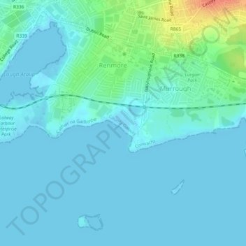
Name: Ballyloughane Beach topographic map, elevation, terrain.
Average elevation: 23 ft
Minimum elevation: -10 ft
Maximum elevation: 148 ft
Other topographic maps
Click on a map to view its topography, its elevation and its terrain.
South Park
Ireland > County Galway > Galway City
South Park, Claddagh, Galway City, County Galway, Connacht, Ireland
Average elevation: 13 ft
Knocknagoneen
Ireland > County Galway > Galway City
Knocknagoneen, Knocknacarragh, Galway City, County Galway, Connacht, H91 R6PW, Ireland
Average elevation: 16 ft
Knocknacarragh
Ireland > County Galway > Galway City
Knocknacarragh, Galway City, County Galway, Connacht, H91 K856, Ireland
Average elevation: 33 ft
Menlo
Ireland > County Galway > Galway City > Menlo
Menlo, Galway City, County Galway, Connacht, H91 CF90, Ireland
Average elevation: 72 ft
Menlough
Ireland > County Galway > Galway City
Menlough, Galway City, County Galway, Connacht, Ireland
Average elevation: 62 ft