
Canary Islands topographic map
Interactive map
Click on the map to display elevation.
About this map
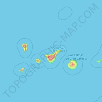
Name: Canary Islands topographic map, elevation, terrain.
Location: Canary Islands, Spain (27.63774 -18.16087 29.41606 -13.33201)
Average elevation: 52 ft
Minimum elevation: 0 ft
Maximum elevation: 11,483 ft
The Canary Islands, especially Tenerife, Gran Canaria, Fuerteventura, and Lanzarote, are a major tourist destination, with over 12 million visitors per year. This is due to their beaches, subtropical climate, and important natural attractions, especially Maspalomas in Gran Canaria, Teide National Park, and Mount Teide (a World Heritage Site) in Tenerife. Mount Teide is the highest peak in Spain and the third tallest volcano in the world, measured from its base on the ocean floor. The islands have warm summers and winters warm enough for the climate to be technically tropical at sea level. The amount of precipitation and the level of maritime moderation vary depending on location and elevation. The archipelago includes green areas as well as desert areas. The islands' high mountains are ideal for astronomical observation, because they lie above the temperature inversion layer. As a result, the archipelago boasts two professional observatories: Teide Observatory on the island of Tenerife, and Roque de los Muchachos Observatory on the island of La Palma.
Other topographic maps
Click on a map to view its topography, its elevation and its terrain.
Valle de Benasque
Valle de Benasque, Benasque, Ribagorza, Aragon, Spain
Average elevation: 6,860 ft
Santa Marta de Tormes
Santa Marta de Tormes, Salamanca, Castile and León, Spain
Average elevation: 2,621 ft
Cuarterón
Spain > Rioja > Cervera del Río Alhama
Cuarterón, Cervera del Río Alhama, Rioja, Spain
Average elevation: 2,362 ft
Tàrbena
Tàrbena, la Marina Baixa, Alacant / Alicante, Valencian Community, Spain
Average elevation: 1,873 ft
Cantón
Spain > Region of Murcia > Oriental > Abanilla
Cantón, Abanilla, Oriental, Region of Murcia, Spain
Average elevation: 1,821 ft
Los Llanos de Aridane
Los Llanos de Aridane, Santa Cruz de Tenerife, Canary Islands, Spain
Average elevation: 1,171 ft
Jimena de la Frontera
Spain > Andalusia > Campo de Gibraltar
Jimena de la Frontera, Campo de Gibraltar, Cádiz, Andalusia, 11339, Spain
Average elevation: 883 ft
Alba de Cerrato
Alba de Cerrato, Palencia, Castile and León, 34219, Spain
Average elevation: 2,713 ft
La Nogada
Spain > Castile and León > Cardeñuela Riopico
La Nogada, Cardeñuela Riopico, Burgos, Castile and León, 09198, Spain
Average elevation: 3,294 ft
Cadalso de los Vidrios
Cadalso de los Vidrios, Community of Madrid, Spain
Average elevation: 2,523 ft
Allariz
Spain > Galicia > Allariz-Maceda
Allariz, Allariz-Maceda, Ourense, Galicia, Spain
Average elevation: 1,903 ft
Rianxo
Spain > Galicia > A Barbanza
Rianxo, A Barbanza, A Coruña, Galicia, Spain
Average elevation: 456 ft
Erill la Vall
Spain > Catalonia > Alta Ribagorça > la Vall de Boí > Boí
Erill la Vall, Boí, la Vall de Boí, Alta Ribagorça, Catalonia, 25528, Spain
Average elevation: 5,246 ft
Santa Ponsa
Spain > Balearic Islands > Serra de Tramuntana
Santa Ponsa, Calvià, Serra de Tramuntana, Balearic Islands, 07180, Spain
Average elevation: 135 ft
Sabadell
Spain > Catalonia > Vallès Occidental
Sabadell, Vallès Occidental, Barcelona, Catalonia, Spain
Average elevation: 600 ft
Murcia
Spain > Region of Murcia > Área Metropolitana de Murcia
Murcia, Área Metropolitana de Murcia, Region of Murcia, Spain
Average elevation: 561 ft
Vilagarcía de Arousa
Vilagarcía de Arousa, O Salnés, Pontevedra, Galicia, Spain
Average elevation: 233 ft
l'Hospitalet de Llobregat
Spain > Catalonia > Barcelonès
l'Hospitalet de Llobregat, Barcelonès, Barcelona, Catalonia, Spain
Average elevation: 102 ft
Guía de Isora
Guía de Isora, Santa Cruz de Tenerife, Canary Islands, Spain
Average elevation: 2,575 ft
Villaverde de Medina
Villaverde de Medina, Valladolid, Castile and León, 47465, Spain
Average elevation: 2,441 ft
Fuente Pila
Spain > Community of Madrid > Navalcarnero
Fuente Pila, Navalcarnero, Community of Madrid, 28600, Spain
Average elevation: 2,070 ft
Tordesillas
Tordesillas, Valladolid, Castile and León, Spain
Average elevation: 2,405 ft
Carballo
Spain > Galicia > Bergantiños
Carballo, Bergantiños, A Coruña, Galicia, 15102, Spain
Average elevation: 472 ft
Cala d'Or
Spain > Balearic Islands > Migjorn > Santanyí
Cala d'Or, Santanyí, Migjorn, Balearic Islands, 07660, Spain
Average elevation: 56 ft
Zizurkil
Spain > Autonomous Community of the Basque Country
Zizurkil, Gipuzkoa, Autonomous Community of the Basque Country, 20159, Spain
Average elevation: 712 ft
Sueca
Sueca, la Ribera Baixa, Valencia, Valencian Community, Spain
Average elevation: 13 ft
La Barganiza
La Barganiza, Siero, Asturias, 33423, Spain
Average elevation: 653 ft
Murchante
Murchante, Erribera / Ribera, 31521, Spain
Average elevation: 1,007 ft
Albox
Spain > Andalusia > Valle del Almanzora
Albox, Valle del Almanzora, Almeria, Andalusia, 04800, Spain
Average elevation: 2,320 ft
Cabana de Bergantiños
Spain > Galicia > Bergantiños
Cabana de Bergantiños, Bergantiños, A Coruña, Galicia, Spain
Average elevation: 554 ft
Wamba
Wamba, Valladolid, Castile and León, 47190, Spain
Average elevation: 2,730 ft
Langa de Duero
Langa de Duero, Soria, Castile and León, Spain
Average elevation: 3,087 ft