
Saint-Barthélemy topographic map
Interactive map
Click on the map to display elevation.
About this map
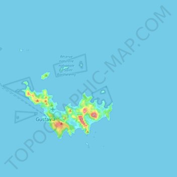
Name: Saint-Barthélemy topographic map, elevation, terrain.
Location: Saint-Barthélemy, 97133, France (17.87082 -62.95112 17.97410 -62.78903)
Average elevation: 13 ft
Minimum elevation: 0 ft
Maximum elevation: 807 ft
Other topographic maps
Click on a map to view its topography, its elevation and its terrain.
Île Fourchue
France > Saint-Barthélemy > Saint-Barthélemy
Île Fourchue, Saint-Barthélemy, 97133, France
Average elevation: 7 ft
Île Chevreau
France > Saint-Barthélemy > Saint-Barthélemy
Île Chevreau, Saint-Barthélemy, 97133, France
Average elevation: 7 ft