
Cerro Aconcagua topographic map
Interactive map
Click on the map to display elevation.
About this map
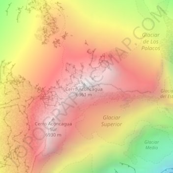
Name: Cerro Aconcagua topographic map, elevation, terrain.
Average elevation: 20,331 ft
Minimum elevation: 16,362 ft
Maximum elevation: 22,792 ft
Other topographic maps
Click on a map to view its topography, its elevation and its terrain.
Andes
Argentina > Mendoza > Distrito Las Cuevas
Andes, Distrito Las Cuevas, Departamento Las Heras, Mendoza, Argentina
Average elevation: 20,367 ft
Aconcagua
Argentina > Mendoza > Distrito Las Cuevas
Aconcagua, Distrito Las Cuevas, Departamento Las Heras, Mendoza, Argentina
Average elevation: 20,344 ft