
Würzburg topographic map
Interactive map
Click on the map to display elevation.
About this map
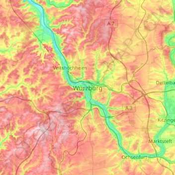
Name: Würzburg topographic map, elevation, terrain.
Location: Würzburg, Lower Franconia, Bavaria, 97070, Germany (49.63245 9.77297 49.95245 10.09297)
Average elevation: 922 ft
Minimum elevation: 525 ft
Maximum elevation: 1,293 ft
Other topographic maps
Click on a map to view its topography, its elevation and its terrain.
Marienberg
Marienberg, Würzburg, Lower Franconia, Bavaria, 97082, Germany
Average elevation: 702 ft