
Sikkim topographic map
Interactive map
Click on the map to display elevation.
About this map
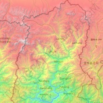
Name: Sikkim topographic map, elevation, terrain.
Location: Sikkim, India (27.07940 88.01203 28.12264 88.92137)
Average elevation: 12,421 ft
Minimum elevation: 866 ft
Maximum elevation: 27,713 ft
Situated in the Himalayan mountains, the state of Sikkim is characterised by mountainous terrain. Almost the entire state is hilly, with an elevation ranging from 280 metres (920 ft) in the south at the border with West Bengal to 8,586 metres (28,169 ft) in northern peaks near Nepal and Tibet. The summit of Kangchenjunga, the world's third-highest peak, is the state's highest point, situated on the border between Sikkim and Nepal. For the most part, the land is unfit for agriculture because of the rocky, precipitous slopes. However, some hill slopes have been converted into terrace farms.
Other topographic maps
Click on a map to view its topography, its elevation and its terrain.
3d
India > Rajasthan > Ganganagar Tehsil > 1 LNP
3d, 1 LNP, Ganganagar Tehsil, Sri Ganganagar District, Rajasthan, India
Average elevation: 584 ft
Mandirbazar
Mandirbazar, South 24 Parganas District, West Bengal, 743336, India
Average elevation: 13 ft
Nankhari
Nankhari, Shimla District, Himachal Pradesh, 172021, India
Average elevation: 6,732 ft
Indian subcontinent
India > Maharashtra > Arni
Indian subcontinent, Arni, Yavatmal, Maharashtra, India
Average elevation: 1,155 ft
Alamboo
India > Rajasthan > Kekri Tehsil
Alamboo, Kekri Tehsil, Ajmer District, Rajasthan, India
Average elevation: 1,165 ft
Chichkheda
India > Madhya Pradesh > Pandhurna Tahsil
Chichkheda, Pandhurna Tahsil, Pandhurna District, Madhya Pradesh, India
Average elevation: 1,663 ft
Naggar
India > Himachal Pradesh > Kullu
Naggar, Kullu, Kullu District, Himachal Pradesh, 175130, India
Average elevation: 6,699 ft
Morshing
India > Arunachal Pradesh > Kalaktang ADC
Morshing, Kalaktang ADC, West Kameng District, Arunachal Pradesh, India
Average elevation: 7,615 ft
Dehradun
India > Uttarakhand > Dehradun
Dehradun, Dehradun District, Uttarakhand, 248001, India
Average elevation: 2,966 ft
Panchgani
India > Maharashtra > Mahabaleshwar
Panchgani, Mahabaleshwar, Satara, Maharashtra, 412805, India
Average elevation: 3,343 ft
Namgial
India > Himachal Pradesh > Poo district
Namgial, Poo district, Kinnaur District, Himachal Pradesh, India
Average elevation: 10,397 ft
Ranipet
India > Tamil Nadu > Wallajah
Ranipet, Wallajah, Ranipet District, Tamil Nadu, 632401, India
Average elevation: 564 ft
Jinnenahalli
India > Karnataka > Channarayapattana taluk
Jinnenahalli, Channarayapattana taluk, Hassan District, Karnataka, 573135, India
Average elevation: 2,831 ft
Jinnaram
India > Telangana > Kotepally mandal
Jinnaram, Kotepally mandal, Vikarabad District, Telangana, 501106, India
Average elevation: 1,801 ft
Deotsidh
India > Himachal Pradesh > Dhatwal
Deotsidh, Dhatwal, Hamirpur District, Himachal Pradesh, 174030, India
Average elevation: 2,365 ft
Anagalapura
India > Karnataka > Bangalore East > Anagalapura
Anagalapura, Bangalore East, Bengaluru Urban, Karnataka, India
Average elevation: 2,917 ft
Jagatpur
India > Odisha > Cuttack (M.Corp.) P.S
Jagatpur, Cuttack (M.Corp.) P.S, Cuttack District, Odisha, India
Average elevation: 75 ft
Ward 61
India > Tamil Nadu > Tiruchirappalli
Ward 61, Trichy Zone IV, Trichy Corporation Limits, Tiruchirappalli, Tiruchirappalli District, Tamil Nadu, India
Average elevation: 292 ft
Sahastradhara
India > Uttarakhand > Dehradun
Sahastradhara, Dehradun, Dehradun District, Uttarakhand, 248009, India
Average elevation: 3,609 ft
Jabalpur
India > Madhya Pradesh > Ranjhi Tahsil
Jabalpur, Ranjhi Tahsil, Jabalpur District, Madhya Pradesh, India
Average elevation: 1,339 ft
Katangi
India > Madhya Pradesh > Katangi Tahsil
Katangi, Katangi Tahsil, Balaghat District, Madhya Pradesh, 481445, India
Average elevation: 1,135 ft
Nimbora
India > Rajasthan > Sirohi Tehsil
Nimbora, Sirohi Tehsil, Sirohi District, Rajasthan, 307802, India
Average elevation: 866 ft
Gaganbavda
India > Maharashtra > Gaganbavda
Gaganbavda, Kolhapur, Maharashtra, 416006, India
Average elevation: 1,539 ft
Kallanai
India > Tamil Nadu > Thiruvaiyaru
Kallanai, Thiruvaiyaru, Thanjavur District, Tamil Nadu, 621601, India
Average elevation: 197 ft
Garur
India > Uttarakhand > Garud
Garur, Garud, Bageshwar District, Uttarakhand, 263641, India
Average elevation: 4,035 ft
Nabagram
Nabagram, Murshidabad District, West Bengal, India
Average elevation: 79 ft
Lambgaon
India > Uttarakhand > Pratapnagar
Lambgaon, Pratapnagar, Tehri Garhwal District, Uttarakhand, 249165, India
Average elevation: 4,911 ft
Rangareddy Palle
India > Telangana > Gandeed mandal
Rangareddy Palle, Gandeed mandal, Mahabubnagar District, Telangana, India
Average elevation: 1,650 ft
Kalavad
India > Gujarat > Kalavad Taluka
Kalavad, Kalavad Taluka, Jamnagar District, Gujarat, 361160, India
Average elevation: 328 ft
Qasba
India > Himachal Pradesh > Palampur
Qasba, Palampur, Kangra District, Himachal Pradesh, 176083, India
Average elevation: 2,631 ft
Mannanthala
India > Kerala > Thiruvananthapuram
Mannanthala, Thiruvananthapuram, Thiruvananthapuram District, Kerala, 695003, India
Average elevation: 167 ft
Nadbai
India > Rajasthan > Nadbai Tehsil
Nadbai, Nadbai Tehsil, Bharatpur District, Rajasthan, 321602, India
Average elevation: 663 ft
Nelamangala taluk
Nelamangala taluk, Bengaluru Rural, Karnataka, India
Average elevation: 2,913 ft
Nagaur
India > Rajasthan > Nagaur Tehsil
Nagaur, Nagaur Tehsil, Nagaur District, Rajasthan, 341001, India
Average elevation: 994 ft
Mahwa Tehsil
Mahwa Tehsil, Dausa District, Rajasthan, India
Average elevation: 801 ft
Ghuttu
India > Uttarakhand > Ghansali
Ghuttu, Ghansali, Tehri Garhwal District, Uttarakhand, India
Average elevation: 6,089 ft
Budha Kedar
India > Uttarakhand > Ghansali
Budha Kedar, Ghansali, Tehri Garhwal District, Uttarakhand, 249125, India
Average elevation: 5,394 ft