
Maharashtra topographic map
Interactive map
Click on the map to display elevation.
About this map
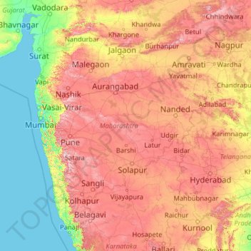
Name: Maharashtra topographic map, elevation, terrain.
Location: Maharashtra, India (15.60636 72.65261 22.03025 80.89778)
Average elevation: 1,135 ft
Minimum elevation: -3 ft
Maximum elevation: 4,652 ft
Maharashtra with a total area of 307,713 km2 (118,809 sq mi), is the third-largest state by area in terms of land area and constitutes 9.36 per cent of India's total geographical area. The State lies between 15°35' N to 22°02' N latitude and 72°36' E to 80°54' E longitude. It occupies the western and central part of the country and has a coastline stretching 840 kilometres along the Arabian Sea. The dominant physical feature of the state is its plateau character, which is separated from the Konkan coastline by the mountain range of the Western Ghats, which runs parallel to the coast from north to south.The Western Ghats, also known as the Sahyadri Range, has an average elevation of 1,200 metres (4,000 ft); its slopes gently descending towards the east and southeast. The Western Ghats (or the Sahyadri Mountain range) provide a physical barrier to the state on the west, while the Satpura Hills along the north and Bhamragad-Chiroli-Gaikhuri ranges on the east serve as its natural borders. This state's expansion from North to South is 700 km and East to West is 800 km. To the west of these hills lie the Konkan coastal plains, 50–80 kilometres in width. To the east of the Ghats lies the flat Deccan Plateau. The main rivers of the state are the Krishna, and its tributary, Bhima, the Godavari, and its main tributaries, Manjara, and Wardha-Wainganga and the Tapi, and its tributary Purna. Maharashtra is divided into five geographic regions. Konkan is the western coastal region, between the Western Ghats and the sea. Khandesh is the north region lying in the valley of the Tapti, Purna river. Nashik, Malegaon Jalgaon, Dhule and Bhusawal are the major cities of this region. Desh is in the center of the state. Marathwada, which was a part of the princely state of Hyderabad until 1956, is located in the southeastern part of the state. Aurangabad and Nanded are the main cities of the region. Vidarbha is the easternmost region of the state, formerly part of the Central Provinces and Berar.
Other topographic maps
Click on a map to view its topography, its elevation and its terrain.
Neamatpur
India > West Bengal > Goalpokhar - II
Neamatpur, Goalpokhar - II, Uttar Dinajpur District, West Bengal, India
Average elevation: 131 ft
Holalkere
India > Karnataka > Holalkere taluk
Holalkere, Holalkere taluk, Chitradurga District, Karnataka, 577526, India
Average elevation: 2,346 ft
Indian subcontinent
India > Maharashtra > Arni
Indian subcontinent, Arni, Yavatmal, Maharashtra, India
Average elevation: 1,155 ft
Model Town Tehsil
Model Town Tehsil, North Delhi District, Delhi, India
Average elevation: 696 ft
3d
India > Rajasthan > Ganganagar Tehsil > 1 LNP
3d, 1 LNP, Ganganagar Tehsil, Sri Ganganagar District, Rajasthan, India
Average elevation: 584 ft
Chandrashila
India > Uttarakhand > Pokhari > Bhulkhana Chatti
Chandrashila, NH107A, Bhulkhana Chatti, Pokhari, Chamoli District, Uttarakhand, India
Average elevation: 10,236 ft
Chatri Nizampur
India > Maharashtra > Mahad
Chatri Nizampur, Mahad, Raigad District, Maharashtra, 402104, India
Average elevation: 1,083 ft
Chikkabidarakallu
India > Karnataka > Bangalore North
Chikkabidarakallu, Bangalore North, Bengaluru Urban, Karnataka, 560073, India
Average elevation: 2,877 ft
Dehradun
India > Uttarakhand > Dehradun
Dehradun, Dehradun District, Uttarakhand, 248001, India
Average elevation: 2,966 ft
Benital
India > Uttarakhand > Karnaprayag
Benital, Karnaprayag, Chamoli District, Uttarakhand, India
Average elevation: 6,070 ft
Wawana
India > Maharashtra > Phulambri
Wawana, Phulambri, Chhatrapati Sambhajinagar District, Maharashtra, India
Average elevation: 2,234 ft
Parbatpur
India > Madhya Pradesh > Sironj Tahsil > Kamariya
Parbatpur, Kamariya, Sironj Tahsil, Vidisha District, Madhya Pradesh, India
Average elevation: 1,627 ft
Songadh
India > Gujarat > Songadh Taluka
Songadh, Songadh Taluka, Tapi District, Gujarat, 394670, India
Average elevation: 407 ft
Mandirbazar
Mandirbazar, South 24 Parganas District, West Bengal, 743336, India
Average elevation: 13 ft
Nankhari
Nankhari, Shimla District, Himachal Pradesh, 172021, India
Average elevation: 6,732 ft
Alamboo
India > Rajasthan > Kekri Tehsil
Alamboo, Kekri Tehsil, Ajmer District, Rajasthan, India
Average elevation: 1,165 ft
Chichkheda
India > Madhya Pradesh > Pandhurna Tahsil
Chichkheda, Pandhurna Tahsil, Pandhurna District, Madhya Pradesh, India
Average elevation: 1,663 ft
Naggar
India > Himachal Pradesh > Kullu
Naggar, Kullu, Kullu District, Himachal Pradesh, 175130, India
Average elevation: 6,699 ft
Jabalpur
India > Madhya Pradesh > Ranjhi Tahsil
Jabalpur, Ranjhi Tahsil, Jabalpur District, Madhya Pradesh, India
Average elevation: 1,339 ft
Morshing
India > Arunachal Pradesh > Kalaktang ADC
Morshing, Kalaktang ADC, West Kameng District, Arunachal Pradesh, India
Average elevation: 7,615 ft
Panchgani
India > Maharashtra > Mahabaleshwar
Panchgani, Mahabaleshwar, Satara, Maharashtra, 412805, India
Average elevation: 3,343 ft
Namgial
India > Himachal Pradesh > Poo district
Namgial, Poo district, Kinnaur District, Himachal Pradesh, India
Average elevation: 10,397 ft
Ranipet
India > Tamil Nadu > Wallajah
Ranipet, Wallajah, Ranipet District, Tamil Nadu, 632401, India
Average elevation: 564 ft
Jinnenahalli
India > Karnataka > Channarayapattana taluk
Jinnenahalli, Channarayapattana taluk, Hassan District, Karnataka, 573135, India
Average elevation: 2,831 ft
Jinnaram
India > Telangana > Kotepally mandal
Jinnaram, Kotepally mandal, Vikarabad District, Telangana, 501106, India
Average elevation: 1,801 ft
Deotsidh
India > Himachal Pradesh > Dhatwal
Deotsidh, Dhatwal, Hamirpur District, Himachal Pradesh, 174030, India
Average elevation: 2,365 ft
Anagalapura
India > Karnataka > Bangalore East > Anagalapura
Anagalapura, Bangalore East, Bengaluru Urban, Karnataka, India
Average elevation: 2,917 ft
Sahastradhara
India > Uttarakhand > Dehradun
Sahastradhara, Dehradun, Dehradun District, Uttarakhand, 248009, India
Average elevation: 3,609 ft
Jagatpur
India > Odisha > Cuttack (M.Corp.) P.S
Jagatpur, Cuttack (M.Corp.) P.S, Cuttack District, Odisha, India
Average elevation: 75 ft
Ward 61
India > Tamil Nadu > Tiruchirappalli
Ward 61, Trichy Zone IV, Trichy Corporation Limits, Tiruchirappalli, Tiruchirappalli District, Tamil Nadu, India
Average elevation: 292 ft
Katangi
India > Madhya Pradesh > Katangi Tahsil
Katangi, Katangi Tahsil, Balaghat District, Madhya Pradesh, 481445, India
Average elevation: 1,135 ft
Nimbora
India > Rajasthan > Sirohi Tehsil
Nimbora, Sirohi Tehsil, Sirohi District, Rajasthan, 307802, India
Average elevation: 866 ft
Gaganbavda
India > Maharashtra > Gaganbavda
Gaganbavda, Kolhapur, Maharashtra, 416006, India
Average elevation: 1,539 ft
Nabagram
Nabagram, Murshidabad District, West Bengal, India
Average elevation: 79 ft
Kallanai
India > Tamil Nadu > Thiruvaiyaru
Kallanai, Thiruvaiyaru, Thanjavur District, Tamil Nadu, 621601, India
Average elevation: 197 ft
Garur
India > Uttarakhand > Garud
Garur, Garud, Bageshwar District, Uttarakhand, 263641, India
Average elevation: 4,035 ft