
Vietnam topographic map
Interactive map
Click on the map to display elevation.
About this map
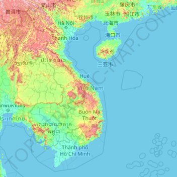
Name: Vietnam topographic map, elevation, terrain.
Location: Vietnam (7.69209 102.14386 23.39269 114.85726)
Average elevation: 568 ft
Minimum elevation: -10 ft
Maximum elevation: 9,213 ft
Due to differences in latitude and the marked variety in topographical relief, Vietnam's climate tends to vary considerably for each region. Vietnam is a country located in the tropics, however Northern Vietnam, including Hanoi, is considered a subtropical region by Köppen climate classification. During the winter or dry season, extending roughly from November to April, the monsoon winds usually blow from the northeast along the Chinese coast and across the Gulf of Tonkin, picking up considerable moisture. The average annual temperature is generally higher in the plains than in the mountains, especially in southern Vietnam compared to the north. Temperatures vary less in the southern plains around Ho Chi Minh City and the Mekong Delta, ranging from between 21 and 35 °C (69.8 and 95.0 °F) over the year. In Hanoi and the surrounding areas of Red River Delta, the temperatures are much lower between 15 and 33 °C (59.0 and 91.4 °F). Seasonal variations in the mountains, plateaus, and the northernmost areas are much more dramatic, with temperatures varying from 3 °C (37.4 °F) in December and January to 37 °C (98.6 °F) in July and August. During winter, snow occasionally falls over the highest peaks of the far northern mountains near the Chinese border. Vietnam receives high rates of precipitation in the form of rainfall with an average amount from 1,500 mm (59 in) to 2,000 mm (79 in) during the monsoon seasons; this often causes flooding, especially in the cities with poor drainage systems. The country is also affected by tropical depressions, tropical storms and typhoons. Vietnam is one of the most vulnerable countries to climate change, with 55% of its population living in low-elevation coastal areas.
Other topographic maps
Click on a map to view its topography, its elevation and its terrain.
United States
United States
Average elevation: 1,014 ft
Ukraine
Ukraine
Average elevation: 600 ft
Seattle
United States > Washington > King County
Seattle, King County, Washington, United States
Average elevation: 131 ft
San Francisco
San Francisco, California, United States
Average elevation: 207 ft
Denver
United States > Colorado > Denver County > Denver
Denver, Denver County, Colorado, United States
Average elevation: 5,525 ft
San Diego
United States > California > San Diego County
San Diego, San Diego County, California, United States
Average elevation: 410 ft
Houston
United States > Texas > Harris County
Houston, Harris County, Texas, United States
Average elevation: 82 ft
Austin
United States > Texas > Travis County
Austin, Travis County, Texas, United States
Average elevation: 709 ft
Salt Lake City
United States > Utah > Salt Lake County
Salt Lake City, Salt Lake County, Utah, United States
Average elevation: 5,223 ft
Portland
United States > Oregon > Multnomah County
Portland, Multnomah County, Oregon, United States
Average elevation: 253 ft
Dallas
United States > Texas > Dallas County
Dallas, Dallas County, Texas, United States
Average elevation: 525 ft
Pittsburgh
United States > Pennsylvania > Allegheny County
Pittsburgh, Allegheny County, Pennsylvania, United States
Average elevation: 994 ft
Atlanta
United States > Georgia > Fulton County
Atlanta, Fulton County, Georgia, United States
Average elevation: 932 ft
Berkeley
United States > California > Alameda County
Berkeley, Alameda County, California, United States
Average elevation: 358 ft
Las Vegas
United States > Nevada > Clark County
Las Vegas, Clark County, Nevada, United States
Average elevation: 2,480 ft
Manhattan
United States > New York > New York County > New York
Manhattan, New York County, New York, United States
Average elevation: 52 ft
Phoenix
United States > Arizona > Maricopa County
Phoenix, Maricopa County, Arizona, United States
Average elevation: 1,578 ft
Roane County
Roane County, East Tennessee, Tennessee, United States
Average elevation: 1,027 ft
Tucson
United States > Arizona > Pima County
Tucson, Pima County, Arizona, United States
Average elevation: 2,697 ft
San Antonio
United States > Texas > Bexar County
San Antonio, Bexar County, Texas, United States
Average elevation: 810 ft
Virginia Beach
United States > Virginia > Virginia Beach
Virginia Beach, Virginia, 23451, United States
Average elevation: 7 ft
Los Angeles
United States > California > Los Angeles County
Los Angeles, California, United States
Average elevation: 791 ft
Kansas City
United States > Missouri > Jackson County
Kansas City, Jackson County, Missouri, United States
Average elevation: 909 ft
Albuquerque
United States > New Mexico > Bernalillo County
Albuquerque, Bernalillo County, New Mexico, United States
Average elevation: 5,538 ft
Milwaukee
United States > Wisconsin > Milwaukee County
Milwaukee, Milwaukee County, Wisconsin, United States
Average elevation: 673 ft
Greenville
United States > South Carolina > Greenville County
Greenville, Greenville County, South Carolina, United States
Average elevation: 951 ft
Maui
United States > Hawaii > Maui County
Maui, Maui County, Hawaii, United States
Average elevation: 761 ft
Saint Petersburg
United States > Florida > Pinellas County
Saint Petersburg, Pinellas County, Florida, United States
Average elevation: 13 ft